Hidden in plain sight
[Update, 7/7/14: Based on photos taken after this post was
published, and a review of the records of the 2011 17th Street canal
remediation project, revisions have been made to this post. It is now
believed the large rocks seen at the base of the 17th Street canal west
side levee in photos taken June 15, 2014 did indeed come from within the levee. Text and photo captions have been adjusted accordingly. Further details and analysis are available at subsequent Fix the Pumps post published July 6, 2014.]
Unreported by anyone, the Corps has begun major work along two outfall canals in New Orleans in the last month. Very long sheet pile is being driven on the 17th Street and London Avenue canals, and rock is going to be placed at the base of the levees inside the canals starting in June or July. These are the same outfall canals that breached in three places in 2005 due to poor design. The ensuing floods of New Orleans devastated hundreds of thousands of lives throughout the greater New Orleans area and beyond.
The Corps' irrational need for secrecy about any work along the outfall canals is long known, but their actually beginning structural work without any public pronouncements, press releases, or whispers in the ears of the mainstream media is unprecedented, especially considering the scale of the work - which is extensive. I think they would rather nobody paid any more attention. But attention should be paid to work at the sites of the cause of the worst engineering disaster in American history.
The work underway already is for seepage control due to existing sheet piling being too short. Seepage happens when water works its way through sand below the bottoms of the I-walls along the canals. Should that water then percolate upward through the land-side (the side where people live) soils, the levee and I-wall can fail. This was the primary mode of failure for the south breach of the London Avenue canal following the 2005 passage of Katrina dozens of miles to the east.
Problems have emerged just weeks into the project, as the soil being dug out of the levees appears to be packed with unacceptable debris like rocks and chunks of concrete. The Corps' own specifications forbid such debris in a levee since it decreases the strength of the soil. However, they have shown they are willing to ignore such specifications during many previous projects both before and since 2005, including a round of projects on all three outfall canals in 2011.
Those 2011 projects included similar seepage remediation work to this present project along the London Avenue canal and the Orleans Avenue canal. The 2011 17th Street project remediated against different modes of failure than seepage, and thus included different technologies than sheet piling.
For calculation purposes, the Corps and their consultants have broken each side of each canal into individual "reaches," based on differing soil and canal bottom conditions. The reaches are numbered sequentially, starting at the south end of the west side of each canal and finishing at the north end of the east side of each canal.
Here's the locations previously remediated along the London Avenue canal in 2011:

And here's the new locations in the 2014 project:

As you can see from the above map, after they are done with this round at London Avenue, nearly the entire canal north of Mirabeau will have had sheet piling placed outside the existing, too-short piling. It points up how poorly the I-walls were designed the first time around, and how inevitable their failure was.
The contract - which includes work at both the London Avenue and 17th Street sites - was awarded February 28, 2014 to Conquistador Dorado JV (aka Dorado Services) out of Sanford, Florida. There are indications Cycle Construction in Kenner is the local partner in the joint venture. The contract - actually a task order on a Service-Disabled Veteran-Owned Small Business (SDVOSB) contract awarded to a pool of four companies - is worth $13,642,238.50 and is scheduled to be completed October 30, 2014, meaning construction will proceed throughout the 2014 hurricane season. Construction along the London Avenue canal started in late May with Reach 12, just north of Filmore Avenue on the west side of the canal.
I have had interested neighbors photographing the work as it proceeds. This photo is from what I believe was the first day piles were driven at the London Avenue canal site, May 29, 2014:

Sheet piling is being driven down to clay approximately 55 feet below sea level. The new sheet piling is being driven a few feet to the protected side of the existing I-wall. The existing sheet piling inside the I-walls goes down to sand about 15 feet below sea level. The Corps is using a pile pressing machine rather than a standard pile driving hammer. The pile presser supposedly creates fewer vibrations and is quieter. It's a machine they've used extensively in the dense urban environment of New Orleans and its surrounding metro area, especially where space is at a premium:

Here's piling being placed the following day:

To make room for the pile presser, the top couple of feet of levee soil next to the I-walls will be stripped off to make a level surface and the dirt stockpiled on the levee itself. Here's the excavators at the London Avenue site:

The sheet piling machine travels along the newly flat section and presses the piling in. This June 6, 2014 photo shows the first few linear feet of piling already driven:

Afterward, the soil will be placed back on top of the piling and grass will be planted. This was done at adjacent Reach 13 in 2011.
If we move closer to the stockpiled soil, details emerge. Worrisome details:

Here's enlargements of the photo above:


All the white bits are broken concrete. This next photo shows it best:

Here's the concrete debris highlighted:
 The dirt
coming out of the levee is absolutely shot through with the stuff.
That's bad. Having debris like concrete in the clay decreases its
strength because it cannot compact properly. Finding debris in these levees is not a surprise, since it was reported on either side of this stretch during the 2011 London Avenue project as well:
The dirt
coming out of the levee is absolutely shot through with the stuff.
That's bad. Having debris like concrete in the clay decreases its
strength because it cannot compact properly. Finding debris in these levees is not a surprise, since it was reported on either side of this stretch during the 2011 London Avenue project as well:

It is one thing to read about it months afterward, and another thing altogether to have pictures of it happening live.
After receiving the pictures of the London site, I asked for pictures of the 17th Street site. Based on those pictures - taken on June 15th, I believe the story is much the same.
The site location on the 17th Street canal is on the west side, just south of I-10:

It is reach 16, which I wrote about extensively 3 years ago. At that time, the Corps was considering placing dirt at the base of the levee on the protected side (outside) of the canal to prevent failure from underseepage. The idea was to provide enough weight on the landside to resist the upward motion of underseeping water. It's an indirect, cheaper way of addressing seepage, as opposed to the direct solution of cutting off the seepage with sheetpile driven into the clay below the sand. It's noteworthy nothing was done in the intervening three years. It's also noteworthy the Corps New Orleans District consultants' calculations in 2010-11 (as well as the Corps' District Engineering folks' marching orders to their consultants before any calculations were performed) claimed there were no seepage problems on reach 16 - or anywhere along the 17th Street canal. Because of that, this newest remediation project is the first one to address seepage concerns along the 17th Street canal. We'll get into what likely changed their mind in future postings.
Here's reach 16 in 2011 (photos taken from the June, 2011 Corps update on that year's remediation projects along the outfall canals):


Construction at the 17th Street canal site also started in late May. The contractor began at the southern end of the site, which is what is shown in the "before" pictures above.
Here's that same end of the site snapped June 15, 2014 (Update, 7/7/14: bottom caption used to read "Dirt placed to make 'road' for crane to travel. Dirt likely not from inside levee"):

I believe that the dirt toward the bottom of the levee is - I hope - fill brought from offsite and placed to allow the crane (which holds the piling vertically) to travel along the levee with the piling pressing machine. I do not think it, and the huge boulders in it, came out of the levee.
[Update, 7/7/14: Based on subsequent photos and a new review of the 2011 remediation project records, it is now believed the material at the bottom of the levee is from inside the levee. This includes the large boulders now visible.]
However, I believe the soil toward the top of the slope is from inside the levee. Even from a distance, we can see the chunks of debris. Getting a closer look shows a large amount of concrete and rocks (Update, 7/7/14: bottom caption used to read "Dirt placed to make 'road' for crane to travel. Dirt likely not from inside levee"):

Here's an enlargement of the above photo:

There's even a stump that appears to be about 2 feet long, just sitting on top of the levee. It seems very likely it came from within the levee (though I suppose it could have come from somewhere else, but then why would it be sitting on the top of the levee?):

Dirt taken out of the southern part of the site is also being stockpiled on the levee near the northern end of the site in front of the end of Lemon St. The copious debris - all the white bits - is obvious (Update, 7/7/14: bottom caption of first two photos used to read "Dirt placed to make 'road' for crane to travel. Dirt likely not from inside levee"):


By any standard, including the Corps', the dirt coming out of the levees at both these sites would be unsuitable for use in any levee. How do we know that? The Corps themselves said so just four years ago, during a different debris mess that made the news.
In late 2009 and early 2010, reports emerged about large amounts of concrete and other debris being found in the top layers of lakefront levee in Kenner during an enlargement project. That soil had been trucked there in the early 2000's and had not been systematically checked for debris. After a couple of Times-Picayune articles, the Corps held a public meeting on January 28, 2010. They showed the following slides as examples of unacceptable amounts of debris in the dirt:
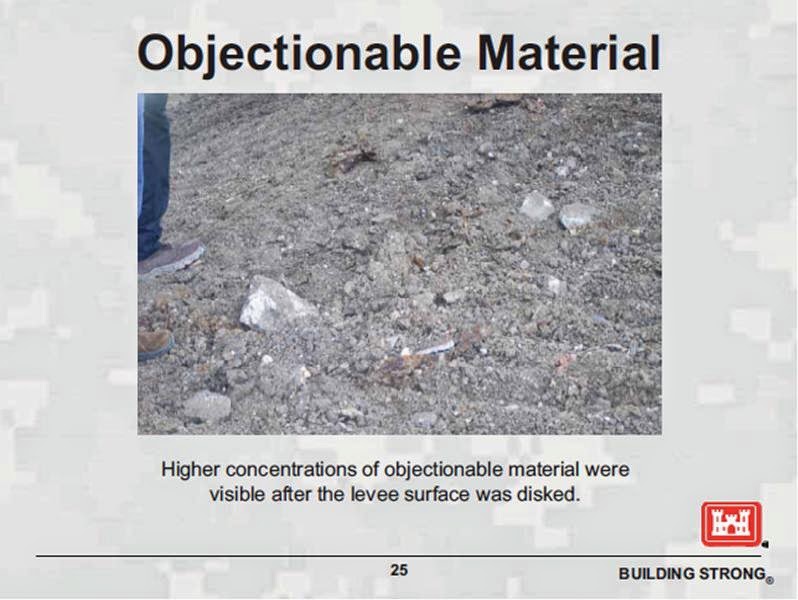

Those photos look eerily similar to the pictures coming out of the London Avenue and 17th Street sites.
The 2010 slides explicitly called out concrete chunks as unacceptable:


In the 2009-10 lakefront case, the Corps' solution - after blaming the previous contractor and prior Corps employees and assuring the public these were isolated instances (which they weren't) - was to remove all the dirt with concrete in it. According to the Corps, the contaminated dirt went down 2.5 feet, so the Corps stripped it all out and replaced it with clean clay.
Here's the scary part: that might not be the plan for the outfall canals, for three reasons:
1) The bid specifications (as amended) for the outfall canal job call for the contractor to place most of the soil they remove from the levee during construction right back in the levee when the sheet piling work is done.
According to those amended specifications, 2350 cubic yards of soil is to be taken out of the levees and reused between the two canal sites. The Corps is only anticipating 650 additional cubic yards between the two sites to be "unsuitable." That is, they expect only one fifth of the total amount of dirt to come out of the levees to stay out, and the rest will go back in. That was the financial basis for awarding the job.
2) We know bad soil with debris just like what we're seeing this year was taken out of outfall canal levees and put back in during the 2011 projects. The Corps' own contractors' said so, doing so under orders from Corps employees.
3) Finally, we know the Corps has no compunction using or reusing debris-laden soil that violates their own specifications all over the greater New Orleans area. Besides the three outfall canal remediation projects in 2011, I counted 22 projects where it happened in the last few years:

For further information, you can consult my 14 (!) part series on debris in the levees. Part 1 is here, with the other parts linked from it. The Corps' use of unacceptable soil seems to be more the norm than the exception.
Why does this matter? After all, there's gates at the ends of the canals to protect them from hurricanes, right?
Well, the outfall canal walls and levees do not care where water comes from - whether it's the lake or the city's pump stations. Even if the lakefront gates are closed and secured during a high lake level event (a big "if," since during the last hurricane 5 of 11 gates at the London Avenue structure were not secured), the city still has to pump rainwater from within the city down the canals. That water level can get quite high - just as high as the water got from Katrina's surge. A levee with concrete in it instead of clay is simply not as strong, and could be prone to, um, difficulties.
In addition, there is the obvious question: if this is what the top couple of feet of the levees along both canals look like, what about the rest of the levee left untouched by these newest projects? Given that these stretches of levee have not been dug into since the failed I-walls were installed about 15 years before their 2005 failure, it is a reasonable concern that the entire levees - including previously remediated stretches - are just as bad as what we've seen here. Without exploratory trenching - as has been done on many other projects where debris was found - there exists a deep trust deficit between the Corps and the public who depend on these levees for their lives and livelihoods.
Unreported by anyone, the Corps has begun major work along two outfall canals in New Orleans in the last month. Very long sheet pile is being driven on the 17th Street and London Avenue canals, and rock is going to be placed at the base of the levees inside the canals starting in June or July. These are the same outfall canals that breached in three places in 2005 due to poor design. The ensuing floods of New Orleans devastated hundreds of thousands of lives throughout the greater New Orleans area and beyond.
The Corps' irrational need for secrecy about any work along the outfall canals is long known, but their actually beginning structural work without any public pronouncements, press releases, or whispers in the ears of the mainstream media is unprecedented, especially considering the scale of the work - which is extensive. I think they would rather nobody paid any more attention. But attention should be paid to work at the sites of the cause of the worst engineering disaster in American history.
The work underway already is for seepage control due to existing sheet piling being too short. Seepage happens when water works its way through sand below the bottoms of the I-walls along the canals. Should that water then percolate upward through the land-side (the side where people live) soils, the levee and I-wall can fail. This was the primary mode of failure for the south breach of the London Avenue canal following the 2005 passage of Katrina dozens of miles to the east.
Problems have emerged just weeks into the project, as the soil being dug out of the levees appears to be packed with unacceptable debris like rocks and chunks of concrete. The Corps' own specifications forbid such debris in a levee since it decreases the strength of the soil. However, they have shown they are willing to ignore such specifications during many previous projects both before and since 2005, including a round of projects on all three outfall canals in 2011.
Those 2011 projects included similar seepage remediation work to this present project along the London Avenue canal and the Orleans Avenue canal. The 2011 17th Street project remediated against different modes of failure than seepage, and thus included different technologies than sheet piling.
For calculation purposes, the Corps and their consultants have broken each side of each canal into individual "reaches," based on differing soil and canal bottom conditions. The reaches are numbered sequentially, starting at the south end of the west side of each canal and finishing at the north end of the east side of each canal.
Here's the locations previously remediated along the London Avenue canal in 2011:
And here's the new locations in the 2014 project:

As you can see from the above map, after they are done with this round at London Avenue, nearly the entire canal north of Mirabeau will have had sheet piling placed outside the existing, too-short piling. It points up how poorly the I-walls were designed the first time around, and how inevitable their failure was.
The contract - which includes work at both the London Avenue and 17th Street sites - was awarded February 28, 2014 to Conquistador Dorado JV (aka Dorado Services) out of Sanford, Florida. There are indications Cycle Construction in Kenner is the local partner in the joint venture. The contract - actually a task order on a Service-Disabled Veteran-Owned Small Business (SDVOSB) contract awarded to a pool of four companies - is worth $13,642,238.50 and is scheduled to be completed October 30, 2014, meaning construction will proceed throughout the 2014 hurricane season. Construction along the London Avenue canal started in late May with Reach 12, just north of Filmore Avenue on the west side of the canal.
I have had interested neighbors photographing the work as it proceeds. This photo is from what I believe was the first day piles were driven at the London Avenue canal site, May 29, 2014:
Sheet piling is being driven down to clay approximately 55 feet below sea level. The new sheet piling is being driven a few feet to the protected side of the existing I-wall. The existing sheet piling inside the I-walls goes down to sand about 15 feet below sea level. The Corps is using a pile pressing machine rather than a standard pile driving hammer. The pile presser supposedly creates fewer vibrations and is quieter. It's a machine they've used extensively in the dense urban environment of New Orleans and its surrounding metro area, especially where space is at a premium:
Here's piling being placed the following day:
To make room for the pile presser, the top couple of feet of levee soil next to the I-walls will be stripped off to make a level surface and the dirt stockpiled on the levee itself. Here's the excavators at the London Avenue site:
The sheet piling machine travels along the newly flat section and presses the piling in. This June 6, 2014 photo shows the first few linear feet of piling already driven:
Afterward, the soil will be placed back on top of the piling and grass will be planted. This was done at adjacent Reach 13 in 2011.
If we move closer to the stockpiled soil, details emerge. Worrisome details:
Here's enlargements of the photo above:
All the white bits are broken concrete. This next photo shows it best:
Here's the concrete debris highlighted:
It is one thing to read about it months afterward, and another thing altogether to have pictures of it happening live.
After receiving the pictures of the London site, I asked for pictures of the 17th Street site. Based on those pictures - taken on June 15th, I believe the story is much the same.
The site location on the 17th Street canal is on the west side, just south of I-10:
It is reach 16, which I wrote about extensively 3 years ago. At that time, the Corps was considering placing dirt at the base of the levee on the protected side (outside) of the canal to prevent failure from underseepage. The idea was to provide enough weight on the landside to resist the upward motion of underseeping water. It's an indirect, cheaper way of addressing seepage, as opposed to the direct solution of cutting off the seepage with sheetpile driven into the clay below the sand. It's noteworthy nothing was done in the intervening three years. It's also noteworthy the Corps New Orleans District consultants' calculations in 2010-11 (as well as the Corps' District Engineering folks' marching orders to their consultants before any calculations were performed) claimed there were no seepage problems on reach 16 - or anywhere along the 17th Street canal. Because of that, this newest remediation project is the first one to address seepage concerns along the 17th Street canal. We'll get into what likely changed their mind in future postings.
Here's reach 16 in 2011 (photos taken from the June, 2011 Corps update on that year's remediation projects along the outfall canals):


Construction at the 17th Street canal site also started in late May. The contractor began at the southern end of the site, which is what is shown in the "before" pictures above.
Here's that same end of the site snapped June 15, 2014 (Update, 7/7/14: bottom caption used to read "Dirt placed to make 'road' for crane to travel. Dirt likely not from inside levee"):
[Update, 7/7/14: Based on subsequent photos and a new review of the 2011 remediation project records, it is now believed the material at the bottom of the levee is from inside the levee. This includes the large boulders now visible.]
However, I believe the soil toward the top of the slope is from inside the levee. Even from a distance, we can see the chunks of debris. Getting a closer look shows a large amount of concrete and rocks (Update, 7/7/14: bottom caption used to read "Dirt placed to make 'road' for crane to travel. Dirt likely not from inside levee"):
Here's an enlargement of the above photo:
Dirt taken out of the southern part of the site is also being stockpiled on the levee near the northern end of the site in front of the end of Lemon St. The copious debris - all the white bits - is obvious (Update, 7/7/14: bottom caption of first two photos used to read "Dirt placed to make 'road' for crane to travel. Dirt likely not from inside levee"):
By any standard, including the Corps', the dirt coming out of the levees at both these sites would be unsuitable for use in any levee. How do we know that? The Corps themselves said so just four years ago, during a different debris mess that made the news.
In late 2009 and early 2010, reports emerged about large amounts of concrete and other debris being found in the top layers of lakefront levee in Kenner during an enlargement project. That soil had been trucked there in the early 2000's and had not been systematically checked for debris. After a couple of Times-Picayune articles, the Corps held a public meeting on January 28, 2010. They showed the following slides as examples of unacceptable amounts of debris in the dirt:

Those photos look eerily similar to the pictures coming out of the London Avenue and 17th Street sites.
The 2010 slides explicitly called out concrete chunks as unacceptable:

In the 2009-10 lakefront case, the Corps' solution - after blaming the previous contractor and prior Corps employees and assuring the public these were isolated instances (which they weren't) - was to remove all the dirt with concrete in it. According to the Corps, the contaminated dirt went down 2.5 feet, so the Corps stripped it all out and replaced it with clean clay.
Here's the scary part: that might not be the plan for the outfall canals, for three reasons:
1) The bid specifications (as amended) for the outfall canal job call for the contractor to place most of the soil they remove from the levee during construction right back in the levee when the sheet piling work is done.
According to those amended specifications, 2350 cubic yards of soil is to be taken out of the levees and reused between the two canal sites. The Corps is only anticipating 650 additional cubic yards between the two sites to be "unsuitable." That is, they expect only one fifth of the total amount of dirt to come out of the levees to stay out, and the rest will go back in. That was the financial basis for awarding the job.
2) We know bad soil with debris just like what we're seeing this year was taken out of outfall canal levees and put back in during the 2011 projects. The Corps' own contractors' said so, doing so under orders from Corps employees.
3) Finally, we know the Corps has no compunction using or reusing debris-laden soil that violates their own specifications all over the greater New Orleans area. Besides the three outfall canal remediation projects in 2011, I counted 22 projects where it happened in the last few years:

For further information, you can consult my 14 (!) part series on debris in the levees. Part 1 is here, with the other parts linked from it. The Corps' use of unacceptable soil seems to be more the norm than the exception.
Why does this matter? After all, there's gates at the ends of the canals to protect them from hurricanes, right?
Well, the outfall canal walls and levees do not care where water comes from - whether it's the lake or the city's pump stations. Even if the lakefront gates are closed and secured during a high lake level event (a big "if," since during the last hurricane 5 of 11 gates at the London Avenue structure were not secured), the city still has to pump rainwater from within the city down the canals. That water level can get quite high - just as high as the water got from Katrina's surge. A levee with concrete in it instead of clay is simply not as strong, and could be prone to, um, difficulties.
In addition, there is the obvious question: if this is what the top couple of feet of the levees along both canals look like, what about the rest of the levee left untouched by these newest projects? Given that these stretches of levee have not been dug into since the failed I-walls were installed about 15 years before their 2005 failure, it is a reasonable concern that the entire levees - including previously remediated stretches - are just as bad as what we've seen here. Without exploratory trenching - as has been done on many other projects where debris was found - there exists a deep trust deficit between the Corps and the public who depend on these levees for their lives and livelihoods.
Labels: 17th Street canal, Debris, London Avenue canal
posted by mcbrid35 at
11:00 AM
|
3 comments


