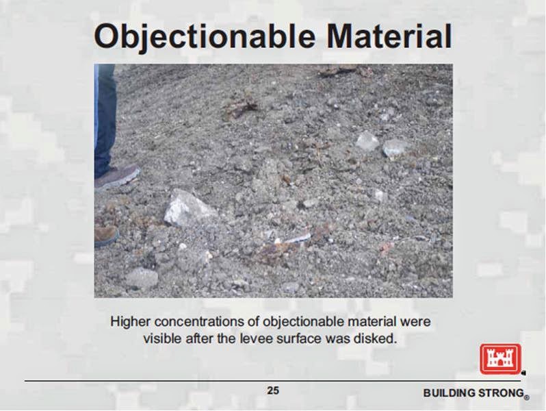
Bricks, rebar, huge rocks inside the 17th Street canal levees (which is no surprise)
The photos showing the unearthing of massive amounts of unsuitable debris from the outfall canal levees this spring and summer bring into stark relief the true nature of flood protection in the greater New Orleans area. By the Corps' own standards, a deeply inadequate system remains in place - a system which under current design and construction guidelines would never get built today. We know this - not by having to plumb endless internal emails or looking through musty, decades-old records - but by simply comparing today's pictures to the records of the last 17th Street canal remediation project conducted just three years ago.
A new round of photos of the Corps of Engineers' 17th Street canal work site taken in late June detail more fully the debris that was piled into the 17th Street canal levees years ago:
Bricks and rebar:

...which we can see after moving closer to the area in red:

Bricks and large rocks:

...which are visible after zooming into the area in red:

None of this should come as a surprise, since the same junk was pulled out the levees a bit north of this year's work site three years ago during the first round of remediation (which I wrote about in 2012). That project offers insights applicable to this year's project.
Extensive "unsuitable" material found inside 17th Street canal levees in 2011
The 2011 17th Street canal remediation project consisted mostly of deep soil mixing of grout with existing soil to improve the strength of the soil along both east and west banks of the canal. Columns of dirt below the base of the levees were mixed with injected grout down to -20 to -40 feet. The contractor had to excavate a few feet off the top of the levee to give a flat platform on which to mount the drilling rigs and other work equipment. Here's the generic cross-sectional detail from the project issued-for-construction drawings showing this:

The excavated material is shown with the single hatching on top of the levee. It was expected to be reused as backfill for the same area at the completion of the project. That's not what happened.
Right from the start and throughout the entire 2011 project, the Corps' contractors continually found the levees on both sides of the canal were riddled with, shall we say, non-dirt objects. The greatest concentration appears to have been on the west - or Jefferson Parish - side. On the very first day of construction on the west bank (March 7, 2011, which was also Lundi Gras), the contractor dug into the levee near the intersection of Orpheum and Rosebud. The contractor's Quality Control report (all reports from the 2011 project are linked from this post) for that day said:
Four days later, March 11th, a decision was made on this "significant debris:"
The 2011 project involved excavating the top of the west bank of the canal from Georgia Court to the Old Hammond Highway bridge, a distance of 3/4's of a mile. Thus, this statement implicitly said that the entire levee along that stretch - at least as deep as the Corps wished to dig but no deeper - was made of dirt not suitable for levee construction:

The Corps' wink-and-a-nod instruction ("excavate to the required depth to build the production platform only") indicated they believed the rest of the levee was similarly riddled, but didn't want to bother dealing with it. That means there's likely still junk in the 17th Street canal levee today, just further down than where the 2011 project dug. Returning to the detail from the drawings, we can see this graphically:

Two weeks after the implicit acknowledgement of the unsuitability of the west side levees, the contractor made it explicit. In the March 24, 2011 Quality Control report they reported on excavation of the west bank levee along Orpheum between Chestnut and West Esplanade:
As I noted when I wrote about this in 2012, at least the Corps didn't try to reuse this junk dirt. But they also didn't bother to tell the public and their government representatives in any meaningful fashion there were "rocks, concrete, bricks, shells, and asphalt" inside 3/4's of a mile of 17th Street canal levee that had been there since it was built decades ago. Or that such debris would remain within the levees even after the project was completed. They just proceeded to conduct business as usual, like it was a normal thing to discover - six years after the fatal failure of their levees - that the levees along the 17th Street canal were built out of trash. Day after day for months, they hauled dirt off the Jefferson Parish levee across the canal to their laydown yard on Bellaire Avenue along the east bank of the canal - in front of the 2005 New Orleans breach location - and told no one in the public the extent of the problem. Some of that bad dirt was spread out at the laydown yard during the summer, 2011 and literally buried under grass. The rest of it, including some stuff too big to be buried, was trucked offsite. The August 23, 2011 quality control report describes this disposition:
Fortunately, three years later during another project involving digging into the Jefferson Parish side of the canal, we have pictures showing us just how poorly these levees were constructed - and indicating how much junk remains inside them today, so there's no way this information can be buried or hauled away again.
Debris so huge it couldn't be removed in 2011, or ever
Some of the junk was so huge in 2011 it couldn't even be moved out of the levee. An extreme example of this was documented by the contractor logs starting on March 25, 2011. That day, there came discovery of a very large concrete "object" just below the west bank levee near the intersection of Orpheum and West Esplanade. From the contractor's quality control report:
The Corps quality assurance report has a little more detail:
That's right: a room sized chunk of concrete buried under the levee that didn't get discovered until the levee was dug out. This was so huge that even the Corps owned up to it, taking pictures two months later when they dealt with the thing:


This mass of concrete was in an area that had been extensively explored by Corps test borings. No fewer than 11 test bores and cone penetrometer tests had been drilled into the levee within 200 feet of this location, 10 of them since the 2005 levee failures, as seen on this detail:

One must ask how such a giant chunk of concrete could be unearthed as a surprise. It also raises the obvious question about the quality of the information gleaned from the test bores and other exploratory drilling the Corps does before a project.
In this particular case, the obstruction was so huge they actually left it in place. After covering it back up in March, they went back in late May. They uncovered the obstruction and then backfilled and compacted the affected area between May 24, 2011 and June 1, 2011. Presumably some work crew 20 years in the future will dig it out again.
Comparing the 2014 project to the 2011 project
Going back and reviewing all the records from the 2011 project has given me a little different perspective on what we can see in the 2014 project photos. During the 2011 project, all the construction on the levee was done with dirt from the levee. This included building of platforms and ramps - things occurring right now during the 2014 project. Clean dirt was not brought into the site in 2011 until all substantial work was completed. I have no reason to think the 2014 project is proceeding any differently.
So unlike what I wrote a couple of weeks back, I now believe that all the soil currently piled up on the levee came out the levee, including the stuff near the base that is acting as a "road" for the crane. This means giant boulders are also coming out of the levee, not just chunks of concrete, brick, and pieces of rebar. Here's a couple of the pictures from my prior entry, relabeled to include that conclusion:


In comparing the progress of the 2014 and 2011 projects, what do we make of the fact the Corps started removing bad dirt from the site within days of unearthing it in 2011, but the junk has remained on the levee for weeks in 2014? Some of the reason might simply be how this year's site is set up. The dirt at the bottom of the levee this year remains in use for access to the entire site, with only a single point of entry or exit for heavy equipment at the south end of the site. The crane using the platform at the levee bottom is needed for the entire duration of the project, which has not been completed yet (the contractor is moving from south to north). So the bad dirt making up the platform probably can't be removed until all the sheet piling has been placed.
Debris throughout the entire 17th Street canal west side levees?
However, the logistics of this year's project are not nearly as important as the larger point: everywhere the inside of the 17th Street canal west side levee has been revealed - whether in 2011 or this year - massive amounts of debris have been found. And even more troubling, there are very long stretches which remain untouched:

Given the shallow depth it was found in 2011 and 2014, it makes sense some of the debris was part of the I-wall and levee construction in the early 1990's. That work did involve placement of dirt on top of the existing levees at the time. It extended the entire length of the canal (all the yellow and red lines shown above). Other, deeper debris has likely been there far longer. The records of nearly every soil boring taken in 1981 along the west bank - long before the I-walls were put in - have numerous mentions of shells, wood, bricks, and other "miscellaneous fill." Those records were used in the basis of design for the Corps' early 1990's work. This junk has been known to the Corps for a very, very long time. It also very likely extends the entire length of the canal on at least the Jefferson Parish side.
How it got there doesn't really matter now though, because all the junk is still there today, and the integrity of the outfall canals remains the responsibility of the Corps. As the decision recorded in the contractor quality control log of March 11, 2011 indicates, there is no way the 17th Street canal west bank levees would be built today with the debris-riddled dirt that is currently sitting in them. That dirt is - according to the Corps - "unsuitable." Yet there the levees sit.
Thus, this is what the Corps considers the recipe for sufficient levees along possibly the most well known stretch of levee in the nation:

These levees do not care what water presses against them - storm surge or rainwater. Thus it make no difference that the outlets of the outfall canals are "protected" by gates now. These levees still see pressure from stormwater during major rainfall events. One must wonder what local government officials and Corps personnel living behind these levees think seeing the true condition of the Corps' flood protection.
A new round of photos of the Corps of Engineers' 17th Street canal work site taken in late June detail more fully the debris that was piled into the 17th Street canal levees years ago:
Bricks and rebar:
...which we can see after moving closer to the area in red:
Bricks and large rocks:
...which are visible after zooming into the area in red:
None of this should come as a surprise, since the same junk was pulled out the levees a bit north of this year's work site three years ago during the first round of remediation (which I wrote about in 2012). That project offers insights applicable to this year's project.
Extensive "unsuitable" material found inside 17th Street canal levees in 2011
The 2011 17th Street canal remediation project consisted mostly of deep soil mixing of grout with existing soil to improve the strength of the soil along both east and west banks of the canal. Columns of dirt below the base of the levees were mixed with injected grout down to -20 to -40 feet. The contractor had to excavate a few feet off the top of the levee to give a flat platform on which to mount the drilling rigs and other work equipment. Here's the generic cross-sectional detail from the project issued-for-construction drawings showing this:

The excavated material is shown with the single hatching on top of the levee. It was expected to be reused as backfill for the same area at the completion of the project. That's not what happened.
Right from the start and throughout the entire 2011 project, the Corps' contractors continually found the levees on both sides of the canal were riddled with, shall we say, non-dirt objects. The greatest concentration appears to have been on the west - or Jefferson Parish - side. On the very first day of construction on the west bank (March 7, 2011, which was also Lundi Gras), the contractor dug into the levee near the intersection of Orpheum and Rosebud. The contractor's Quality Control report (all reports from the 2011 project are linked from this post) for that day said:
"Visually inspected the construction of the West Bank production pad. Material removed from the existing levee between stations 588+00 and 590+00 contained significant debris (rocks, concrete, bricks, shells, asphalt). Informed Bill and Derrick [Corps employees Bill Richardson and Derrick Parker] and they came over to look. We asked they to determine if this would be considered "unsuitable" to reuse in the construct of the levee"
Four days later, March 11th, a decision was made on this "significant debris:"
"Got a verbal answer from [Corps employee] Bill Richardson concerning the 'unsuitable material' encountered during the excavation of the West Bank platform. We are to excavate to the required depth to build the production platform only. All excavated material will be hauled offsite and replaced with suitable clay material from the Bonnet Carre borrow pit."
The 2011 project involved excavating the top of the west bank of the canal from Georgia Court to the Old Hammond Highway bridge, a distance of 3/4's of a mile. Thus, this statement implicitly said that the entire levee along that stretch - at least as deep as the Corps wished to dig but no deeper - was made of dirt not suitable for levee construction:
The Corps' wink-and-a-nod instruction ("excavate to the required depth to build the production platform only") indicated they believed the rest of the levee was similarly riddled, but didn't want to bother dealing with it. That means there's likely still junk in the 17th Street canal levee today, just further down than where the 2011 project dug. Returning to the detail from the drawings, we can see this graphically:

Two weeks after the implicit acknowledgement of the unsuitability of the west side levees, the contractor made it explicit. In the March 24, 2011 Quality Control report they reported on excavation of the west bank levee along Orpheum between Chestnut and West Esplanade:
"Excavation (degrading/construction of production platform) on West side of canal today from station 581+80 to 579+00 to an elevation of +1.8 to +1.5'. All degraded material was hauled to laydown area on the East side of the canal. Material was considered unsuitable by USACE and will be stockpiled in laydown area on east side of the canal. The material will then be spread throughout the laydown yard at the end of the project per USACE direction."
As I noted when I wrote about this in 2012, at least the Corps didn't try to reuse this junk dirt. But they also didn't bother to tell the public and their government representatives in any meaningful fashion there were "rocks, concrete, bricks, shells, and asphalt" inside 3/4's of a mile of 17th Street canal levee that had been there since it was built decades ago. Or that such debris would remain within the levees even after the project was completed. They just proceeded to conduct business as usual, like it was a normal thing to discover - six years after the fatal failure of their levees - that the levees along the 17th Street canal were built out of trash. Day after day for months, they hauled dirt off the Jefferson Parish levee across the canal to their laydown yard on Bellaire Avenue along the east bank of the canal - in front of the 2005 New Orleans breach location - and told no one in the public the extent of the problem. Some of that bad dirt was spread out at the laydown yard during the summer, 2011 and literally buried under grass. The rest of it, including some stuff too big to be buried, was trucked offsite. The August 23, 2011 quality control report describes this disposition:
"East side of the canal - Spreading unsuitable material in laydown yard per USACE's direction. Large debris is being removed and stockpiled to be hauled off at later date."
Fortunately, three years later during another project involving digging into the Jefferson Parish side of the canal, we have pictures showing us just how poorly these levees were constructed - and indicating how much junk remains inside them today, so there's no way this information can be buried or hauled away again.
Debris so huge it couldn't be removed in 2011, or ever
Some of the junk was so huge in 2011 it couldn't even be moved out of the levee. An extreme example of this was documented by the contractor logs starting on March 25, 2011. That day, there came discovery of a very large concrete "object" just below the west bank levee near the intersection of Orpheum and West Esplanade. From the contractor's quality control report:
"During the construction of the production platform on the west side of the canal, a large concrete structure was exposed at approximately station 577+80. CKY excavated around object to try and see the size of the object and how to remove object. The size of the concrete object was found to be approximately 20'x13' with rebar protruding out of the concrete. Object was unable to be removed. USACE was contacted about the object and pictures were taken. GPS was used to mark the location of the object. The USACE will be asked in an RFI [request for information] if only elements ABC can be installed at this location due to the large concrete object."
The Corps quality assurance report has a little more detail:
"The concrete footing is quote [sic] thick, it could exceed 2 feet. The footing consists of spread footings that cover the area between stations 577+81.5 and 577+90.5. The depth, below levee grade, is near the elevation of the adjacent road."
That's right: a room sized chunk of concrete buried under the levee that didn't get discovered until the levee was dug out. This was so huge that even the Corps owned up to it, taking pictures two months later when they dealt with the thing:


This mass of concrete was in an area that had been extensively explored by Corps test borings. No fewer than 11 test bores and cone penetrometer tests had been drilled into the levee within 200 feet of this location, 10 of them since the 2005 levee failures, as seen on this detail:

One must ask how such a giant chunk of concrete could be unearthed as a surprise. It also raises the obvious question about the quality of the information gleaned from the test bores and other exploratory drilling the Corps does before a project.
In this particular case, the obstruction was so huge they actually left it in place. After covering it back up in March, they went back in late May. They uncovered the obstruction and then backfilled and compacted the affected area between May 24, 2011 and June 1, 2011. Presumably some work crew 20 years in the future will dig it out again.
Comparing the 2014 project to the 2011 project
Going back and reviewing all the records from the 2011 project has given me a little different perspective on what we can see in the 2014 project photos. During the 2011 project, all the construction on the levee was done with dirt from the levee. This included building of platforms and ramps - things occurring right now during the 2014 project. Clean dirt was not brought into the site in 2011 until all substantial work was completed. I have no reason to think the 2014 project is proceeding any differently.
So unlike what I wrote a couple of weeks back, I now believe that all the soil currently piled up on the levee came out the levee, including the stuff near the base that is acting as a "road" for the crane. This means giant boulders are also coming out of the levee, not just chunks of concrete, brick, and pieces of rebar. Here's a couple of the pictures from my prior entry, relabeled to include that conclusion:
In comparing the progress of the 2014 and 2011 projects, what do we make of the fact the Corps started removing bad dirt from the site within days of unearthing it in 2011, but the junk has remained on the levee for weeks in 2014? Some of the reason might simply be how this year's site is set up. The dirt at the bottom of the levee this year remains in use for access to the entire site, with only a single point of entry or exit for heavy equipment at the south end of the site. The crane using the platform at the levee bottom is needed for the entire duration of the project, which has not been completed yet (the contractor is moving from south to north). So the bad dirt making up the platform probably can't be removed until all the sheet piling has been placed.
Debris throughout the entire 17th Street canal west side levees?
However, the logistics of this year's project are not nearly as important as the larger point: everywhere the inside of the 17th Street canal west side levee has been revealed - whether in 2011 or this year - massive amounts of debris have been found. And even more troubling, there are very long stretches which remain untouched:
Given the shallow depth it was found in 2011 and 2014, it makes sense some of the debris was part of the I-wall and levee construction in the early 1990's. That work did involve placement of dirt on top of the existing levees at the time. It extended the entire length of the canal (all the yellow and red lines shown above). Other, deeper debris has likely been there far longer. The records of nearly every soil boring taken in 1981 along the west bank - long before the I-walls were put in - have numerous mentions of shells, wood, bricks, and other "miscellaneous fill." Those records were used in the basis of design for the Corps' early 1990's work. This junk has been known to the Corps for a very, very long time. It also very likely extends the entire length of the canal on at least the Jefferson Parish side.
How it got there doesn't really matter now though, because all the junk is still there today, and the integrity of the outfall canals remains the responsibility of the Corps. As the decision recorded in the contractor quality control log of March 11, 2011 indicates, there is no way the 17th Street canal west bank levees would be built today with the debris-riddled dirt that is currently sitting in them. That dirt is - according to the Corps - "unsuitable." Yet there the levees sit.
Thus, this is what the Corps considers the recipe for sufficient levees along possibly the most well known stretch of levee in the nation:
These levees do not care what water presses against them - storm surge or rainwater. Thus it make no difference that the outlets of the outfall canals are "protected" by gates now. These levees still see pressure from stormwater during major rainfall events. One must wonder what local government officials and Corps personnel living behind these levees think seeing the true condition of the Corps' flood protection.
Labels: 17th Street canal, Debris
posted by mcbrid35 at
9:02 PM
|
4 comments