Debris Part 14
Part 1
Part 2
Part 3
Part 4
Part 5
Part 6
Part 7
Part 8
Part 9
Part 10
Part 11
Part 12
Part 13
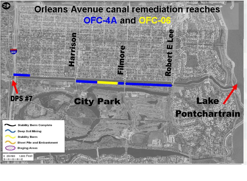
Let's move along to the Orleans Avenue canal. As before, a main source of information is the contractor's Quality Control (QC) and the Corps' Quality Assurance (QA) reports. There were two projects at the Orleans Avenue canal, OFC-4A (which is what most of the work was conducted under; prime contractor IPS, same as on London Avenue) and OFC-06 (which consisted only of installation of a stability berm along one reach on the east bank of the canal between Harrison and Filmore; prime contractor Progressive, with Cycle Construction performing all actual work):
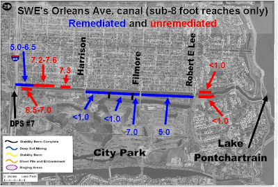
 As with other projects, the Corps didn't remediate everything that had a Safe Water Elevation below their target of 8 feet (we don't know why):
 Here's the QC and QA reports for both projects:
OFC-4A QC reports March 1, 2011 - May 31, 2011
OFC-4A QC reports May 31, 2011 - August 21, 2011
OFC-4A QA reports March 1, 2011 - May 31, 2011
OFC-4A QA reports May 31, 2011 - August 11, 2011
OFC-06 QC reports January 6, 2011 - March 30, 2011
OFC-06 QC reports May 23, 2011 - July 28, 2011
OFC-06 QA reports January 6, 2011 - March 30, 2011
OFC-06 QA reports May 23, 2011 - July 28, 2011
All the quotes in this post, unless otherwise noted, are taken from the QC reports.
There don't seem to be any debris problems with much smaller project OFC-06. However, the very existence of OFC-06 provides a fascinating story I'll get into later.
At OFC-4A, there were substantial debris problems, both with the existing levee and with the new work. We'll start near the end of the project, in June, 2011.
Corps leaves jet grout spoils in levee
Part of the project involved installation of sheet piling on the west bank of the canal under the I-610 bridge. The contractor ran into problems on June 1, 2011 when they happened on existing sheet piling that could not be removed. The following day there was a meeting of the minds:
Here's a picture of the area of concern, taken from a June 8, 2011 update given by the Corps to the Southeast Louisiana Flood Protection Authority - East:
 They kept trying to pull out the piles for four days after that, but they eventually stopped. Another meeting was held on site on June 9th:
So they would be using jet grouting to stabilize the tie-in between the new sheet piling and the old. Jet grouting is a process where a grouty slurry is injected into the soil and allowed to harden, forming a substance called "soilcrete." Sometimes the injected substance is just grout, sometimes there's air added, and sometimes there's air and water added. It's been used all over the greater New Orleans area since the 2005 levee failures. More detail about the process is available at Hayward Baker's website.
Preparation work for the jet grouting began on June 14th:
Now there's two ways to take that. From what I've learned about jet grouting, sometimes the spoils (the stuff that bubbles back to the surface after injecting the grout down into the soil) are routed to a trench so they don't spread all over the place. Then they are disposed of. Under Corps specifications for this project, and indeed every project, jet grouting spoils (a kind of cementy, dirty slurry) were "unsuitable material," and were to be disposed of from the project site within 48 hours. They can't be left inside the levee because they're not the right density. In other words, they're trash. So the above passage could be taken as routine preps to simply contain the spoils for later disposal. Or it could be read as a CYA by the contractor to let future readers know that jet grout spoils were to be left inside the levee. I believe it's the latter.
The prep work continued for a few days, and then on June 21st the jet grouting began:
So they were trenching to collect the spoils. But more importantly, they also deliberately left spoils in the levee. This went on for two more days.
June 22:
June 23:
A subsequent paragraph in the June 23rd report gives the impression they were trying to hide the fact spoils were being used as levee backfill:
There is no doubt jet grout spoils are supposed to be disposed of. From the Corps' own specifications:
Hayward Baker, the company doing the jet grouting, also has model specifications available on their website. Here's what they say about spoils:
To put it simply, the Corps deliberately ignored their own specifications and their own contractor's published guidance and left unsuitable material inside the Orleans Avenue canal levees on June 21-23, 2011.
Stumps, light pole foundations, trash
All the following quotes are taken directly from the contractor QC reports. They speak for themselves.
March 24:
April 11:
April 12
May 6
May 12:
May 17:
May 24:
May 25:
June 1:
June 6:
June 8:
These only represent what was found at the sections into which they dug. Are we seriously supposed to believe that the sections of levee untouched by this project are pristine after reading this stuff? 10'x12' stumps and concrete light pole foundations do not make for reliable levees.
Part of levee missing since 1997?
I recently obtained the latest iteration of the Corps' safe water elevation (SWE) reports. They've been rechristened "Mean Operating Water Level" (MOWL) reports and were issued in April, 2011:
17th Street
Orleans Avenue
London Avenue
The substance of the reports remains the same, but There have been significant revisions to calculations between the October, 2010 versions and these April, 2011 ones, plus they read much more smoothly now.
In the Orleans Avenue canal report, though, I came upon this new verbiage:
Now it's bad enough there were at least were four reaches which could not meet the Corps' standards when the water was simply at normal tidal levels. In fact, reaches 10B and 20B were not included in the remediation project. But what I highlighted above is even worse.
What that's saying when you cut through the Corps-ese and check the drawings is that a part of the levee on the Orleans Avenue canal which was supposed to be built in the 1990's was not actually there, and the Corps didn't discover this until 2010.
Reach 18A is here, on the east bank of the canal between Harrison and Filmore Avenues, across from City Park:

It extends 1100 feet. It was supposed to have a stability berm - a bunch of dirt intended to keep the levee and I-wall in place - that extended from about 30 feet from the I-wall to about 90 feet from the I-wall. Indeed, the as-built drawings of the 1997 project - submitted in June, 1998 after the project was completed - do show such a berm on the cross sections:

What the Corps found in May, 2010 was that the berm was considerably short on width. Here's cross sections of Reaches 17 and 18A drawn from data collected during the 2010 survey. Like 18A, Reach 17 was also supposed to have a stability berm:

While the 2010 survey confirmed the existence of the Reach 17 berm extending the proper 60 feet from the levee toe (or about 90 feet from the I-wall), the Reach 18A berm extended only to about 30 feet from the levee toe (or about 60 feet from the I-wall). So a 30 foot by 1100 foot by 2 foot thick section of levee appears to have never been built, or was modified post-construction, or was modified during construction but the modification was left out of the as-built drawings. Then it went hidden in plain sight for possibly 13 years, five of which were after the 2005 levee failures. Additionally, in 1998 the contractor's Corps overseers submitted as-built drawings showing the stability berm as completed, and the Corps Engineering Division accepted them.
The very existence of contract OFC-06 - a contract which appears to be designed solely to put in place work which was supposedly done in 1997 - raises all kinds of questions about what was going on in the Corps' offices before August 29, 2005, as well as since the storm. It also shows it may have been pure luck that none of the walls along the Orleans Avenue canal did not fail in 2005.
Summing up
So here's what we learned from the 2011 Orleans Avenue canal remediation QC reports and the new (April, 2011) "Mean Operating Water Level" (MOWL) reports:
1) The Corps went against their own specifications and industry standard - for unknown reasons - and deliberately left unsuitable material, known as "spoils," in the Orleans Avenue canal levee at the conclusion of three days of jet grouting in late June, 2011.
2) When the Corps' contractors dug into the Orleans Avenue levees during the remediation project, or when they tried to place sheet pile or deep soil mixing columns, they ran into obstruction after obstruction for months. Among the pieces of junk found in the levees were two concrete lightpost foundations, many, many cypress tree stumps (some as big as 12 feet), and assorted trash and junk.
3) Only in 2010 did the Corps discover that 1100 feet of the east bank levee between Harrison and Filmore Avenues was missing approximately 30 feet of stability berm which was supposed to have been there since the 1997 construction of the I-walls on that side of the canal. That stretch was remediated in 2011 with a dedicated contract. Nonetheless, it appears the levee along that stretch may have been unfinished for 14 years, including six years post-Federal Flood, despite as built drawings from 1998 showing the complete berm in place.
Inthe next entry the entry after the next entry, I'll tie up the last three posts in a bow and reveal that the Corps will be doing more remediation work along all three outfall canals in the near future.
Part 2
Part 3
Part 4
Part 5
Part 6
Part 7
Part 8
Part 9
Part 10
Part 11
Part 12
Part 13
Let's move along to the Orleans Avenue canal. As before, a main source of information is the contractor's Quality Control (QC) and the Corps' Quality Assurance (QA) reports. There were two projects at the Orleans Avenue canal, OFC-4A (which is what most of the work was conducted under; prime contractor IPS, same as on London Avenue) and OFC-06 (which consisted only of installation of a stability berm along one reach on the east bank of the canal between Harrison and Filmore; prime contractor Progressive, with Cycle Construction performing all actual work):

OFC-4A QC reports March 1, 2011 - May 31, 2011
OFC-4A QC reports May 31, 2011 - August 21, 2011
OFC-4A QA reports March 1, 2011 - May 31, 2011
OFC-4A QA reports May 31, 2011 - August 11, 2011
OFC-06 QC reports January 6, 2011 - March 30, 2011
OFC-06 QC reports May 23, 2011 - July 28, 2011
OFC-06 QA reports January 6, 2011 - March 30, 2011
OFC-06 QA reports May 23, 2011 - July 28, 2011
All the quotes in this post, unless otherwise noted, are taken from the QC reports.
There don't seem to be any debris problems with much smaller project OFC-06. However, the very existence of OFC-06 provides a fascinating story I'll get into later.
At OFC-4A, there were substantial debris problems, both with the existing levee and with the new work. We'll start near the end of the project, in June, 2011.
Corps leaves jet grout spoils in levee
Part of the project involved installation of sheet piling on the west bank of the canal under the I-610 bridge. The contractor ran into problems on June 1, 2011 when they happened on existing sheet piling that could not be removed. The following day there was a meeting of the minds:
"USACE RE [Resident Engineer], PE [Project Engineer] and QC [contractor quality control rep] were on site in order to evaluate the situation of removing the existing sheet piles under the I-610 bridge. USACE PE instructed that due to the inability to remove the existing piles we will tie into them. USACE PE is looking into whether or not jet grouting will be required to ensure stabilization"
Here's a picture of the area of concern, taken from a June 8, 2011 update given by the Corps to the Southeast Louisiana Flood Protection Authority - East:

"Meeting held on site with Hayward Baker PM, HB Super, HPO PM, USACE RE and QA, IPS QCM and Super [i.e. Hayward Baker (the jet grouting contractor), the Corps, and IPS (the prime contractor)]. Meeting was held at the site where the jet grouting will take place. Discussed the column location and the columns' width and how many would be installed. USACE RE state that the change order request was being issued to IPS in the next 24 hours and wanted Hayward Baker and IPS to start coordinating the work to be performed. He state that the submittals needed first would be equipment and the work plan. Hayward Baker will submit same mix design as used on previous Corps project."
So they would be using jet grouting to stabilize the tie-in between the new sheet piling and the old. Jet grouting is a process where a grouty slurry is injected into the soil and allowed to harden, forming a substance called "soilcrete." Sometimes the injected substance is just grout, sometimes there's air added, and sometimes there's air and water added. It's been used all over the greater New Orleans area since the 2005 levee failures. More detail about the process is available at Hayward Baker's website.
Preparation work for the jet grouting began on June 14th:
"Sealevel began installing backfill for sheet pile trench from STA 12+10 through STA 3+80. STA 3+80 through STA 2+00 left open intentionally to backfill trench with jet grout waste"
Now there's two ways to take that. From what I've learned about jet grouting, sometimes the spoils (the stuff that bubbles back to the surface after injecting the grout down into the soil) are routed to a trench so they don't spread all over the place. Then they are disposed of. Under Corps specifications for this project, and indeed every project, jet grouting spoils (a kind of cementy, dirty slurry) were "unsuitable material," and were to be disposed of from the project site within 48 hours. They can't be left inside the levee because they're not the right density. In other words, they're trash. So the above passage could be taken as routine preps to simply contain the spoils for later disposal. Or it could be read as a CYA by the contractor to let future readers know that jet grout spoils were to be left inside the levee. I believe it's the latter.
The prep work continued for a few days, and then on June 21st the jet grouting began:
"Hayward Baker began installing jet grout columns under the I-610 bridge. Baker began with the 1st 4' diameter column. The columns installed were 65' in length...
IPS was responsible for handling the jet grout spoils. IPS dug trenches along the jet grout area so the spoils could run into the sheet pile trench. The spoils were placed from STA 1+97 through 2+45. About 30 cubic yards of spoils were removed from the trench and designated for removal from site tomorrow. The remainder of the spoils is being used as backfill."
So they were trenching to collect the spoils. But more importantly, they also deliberately left spoils in the levee. This went on for two more days.
June 22:
"IPS is responsible for handling the jet grout spoils. IPS dug trenches along the jet grout area so the spoils could run into the sheet pile trench. The spoils were placed from STA 1+97 through 2+45. About 15 cubic yards of spoils were removed from the trench and designated for removal from site tomorrow. The remainder of the spoils is being used as backfill. IPS hauled out excess spoils from the site."
June 23:
"IPS is responsible for handling the jet grout spoils. IPS dug trenches along the jet grout area so the spoils could run into the sheet pile trench. The spoils were placed from STA 1+97 through 2+45 and STA 2+45 through STA 3+70. The spoils used for backfill were left 12" below the sheet pile top elevation and 18" below the top of final grade for STA 2+40 through STA 1+98."
A subsequent paragraph in the June 23rd report gives the impression they were trying to hide the fact spoils were being used as levee backfill:
"QC Manager inspected the installation of one 4' diameter 65' jet grout columns under the I-610 bridge. Inspected the placement of the spoils from jet grout columns into the PZ27 sheet pile trench. The spoils were placed at least 18" below the final grade where dirt is to be placed and grass is to be grown."
There is no doubt jet grout spoils are supposed to be disposed of. From the Corps' own specifications:
"3.7.4 Disposal of Spoil
The Contractor shall remove all waste and all spoil materials produced as a result of the ground improvement operation and remove the materials from the job site as part of the contract price."
- Section 31 32 13.00 12, 'Ground Improvement'"
Hayward Baker, the company doing the jet grouting, also has model specifications available on their website. Here's what they say about spoils:
"At completion of daily Jet Grouting operations, thoroughly clean site and dispose of all spoil debris, water, and spilled material. Spoil stockpiling overnight is permitted prior to transfer to a predetermined waste or fill location."
To put it simply, the Corps deliberately ignored their own specifications and their own contractor's published guidance and left unsuitable material inside the Orleans Avenue canal levees on June 21-23, 2011.
Stumps, light pole foundations, trash
All the following quotes are taken directly from the contractor QC reports. They speak for themselves.
March 24:
"While clearing and grubbing [subcontractor] Newline encountered chunks of concrete and 3.5" pipe that was in the soil. The debris will be removed prior to any embankment operations take [sic] place"
April 11:
[During initial excavation of area under I-610 bridge]
"[Sheet pile prep work subcontractor] Sealevel has found large obstructions in the excavated areas. Obstructions include concrete, rebar, trash, and other miscellaneous materials"
April 12
"Sealevel continued to excavate trench for sheet pile installation. Still, they are finding obstructions in the clay. Obstructions are being documented by photographs. RFI is being worked on for replacing [with] suitable material."
May 6
"[Dry soil mixing subcontractor] Hayward Baker installed test columns for ground improvements. Test columns were installed at STA 46+00. The first two test holes were abandoned due to Hayward Baker hitting concrete 4 meters into the hole."
May 12:
"[Prime contractor] IPS excavated 9' down and found a 4' in diameter cypress stump... the excavation was backfilled"
May 17:
"Sealevel began installing the 2nd PZ27 sheet pile but had to extract the sheet due to an obstruction hit 10' into the soil. Sealevel excavated the obstruction and uncovered a large cypress stump that was 5' in diameter and at least 4.5' deep. A RFI was inputted to USACE about the removal of the obstruction. Sealevel plans to mob[ilize] in a tiger tooth attachment to tear the stump up tomorrow."
May 24:
"When [sheet pile installation subcontractor] Blue Iron was driving the 10th pile for the day at STA 6+54 through STA 6+58 the encountered an obstruction 3' deep that they could not penetrate. It was too late in the day to begin excavation to investigate what the obstruction is. It seems to be concrete but IPS can not confirm until the obstruction is excavated. IPS will excavate the obstruction in the morning."
May 25:
"Obstruction at STA 6+54 through STA 6+58 was an old concrete light post foundation that was 5.5' in length and the girth was 8.5'. The concrete post was excavated and removed and the excavation was backfilled with suitable material.
At STA 6+62 through STA 6+66 Blue Iron hit another obstruction 4' into the soil. IPS uncovered the obstruction and uncovered another light post foundation the same size as the one found at STA 6+54. Total time lost due to the obstructions was 6 hours. IPS backfilled that excavation as well and compacted the fill."
June 1:
"At approximately 0930 hit an obstruction during installation of the PZC18's. Sealevel excavated and removed a 10'x12' cypress stump. It caused a delay of 4 hours.
At approximately 1700 HBI [Hayward Baker] encountered a large tree stump while installing Ground Improvement Column 62A. After several hours of trying to remove the stump the USACE RE [Resident Engineer] was contacted and we were told to move the columns 3' to the south. Due to the stump's size it broke several tools on the drill and the rest of the day was spent repairing the tools."
June 6:
"Sealevel large cypress tree stump at 2+65"
June 8:
"Blue Iron hit an obstruction at STA 10+90 while driving the PZC 18 sheet piles. The obstruction was 4' deep, IPS excavated the obstruction and found a cypress stump that was approximately 6' in diameter and 5' deep. The obstruction was removed and the excavation was backfilled and compacted."
These only represent what was found at the sections into which they dug. Are we seriously supposed to believe that the sections of levee untouched by this project are pristine after reading this stuff? 10'x12' stumps and concrete light pole foundations do not make for reliable levees.
Part of levee missing since 1997?
I recently obtained the latest iteration of the Corps' safe water elevation (SWE) reports. They've been rechristened "Mean Operating Water Level" (MOWL) reports and were issued in April, 2011:
17th Street
Orleans Avenue
London Avenue
In the Orleans Avenue canal report, though, I came upon this new verbiage:
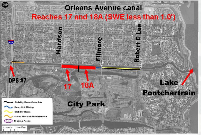
"The FOS calculated by the Spencer’s Method of analysis for Reaches 10B, 17, 18A, and 20B are slightly less than the required 1.4 with the water level in the canal at El 1.0 NAVD88. This water level corresponds with the normal Lake water level. This indicates an inadequate FOS without the influence of the canal water load. These low FOS were the result of the low shear strengths identified in the 2010 CPTs advanced at the toe of these levees. Reach 18A was designed with a protected side stabilization berm extending approximately 90 feet from the I-Wall. This berm is shown in DM-19 [6] and on the “as-built” drawings [11]. The topographic survey performed in 2010 [12] indicated that the berm width was about 30 feet in this reach."
Now it's bad enough there were at least were four reaches which could not meet the Corps' standards when the water was simply at normal tidal levels. In fact, reaches 10B and 20B were not included in the remediation project. But what I highlighted above is even worse.
What that's saying when you cut through the Corps-ese and check the drawings is that a part of the levee on the Orleans Avenue canal which was supposed to be built in the 1990's was not actually there, and the Corps didn't discover this until 2010.
Reach 18A is here, on the east bank of the canal between Harrison and Filmore Avenues, across from City Park:
It extends 1100 feet. It was supposed to have a stability berm - a bunch of dirt intended to keep the levee and I-wall in place - that extended from about 30 feet from the I-wall to about 90 feet from the I-wall. Indeed, the as-built drawings of the 1997 project - submitted in June, 1998 after the project was completed - do show such a berm on the cross sections:

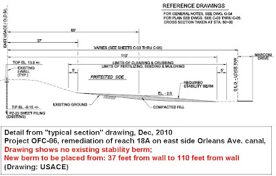
What the Corps found in May, 2010 was that the berm was considerably short on width. Here's cross sections of Reaches 17 and 18A drawn from data collected during the 2010 survey. Like 18A, Reach 17 was also supposed to have a stability berm:

While the 2010 survey confirmed the existence of the Reach 17 berm extending the proper 60 feet from the levee toe (or about 90 feet from the I-wall), the Reach 18A berm extended only to about 30 feet from the levee toe (or about 60 feet from the I-wall). So a 30 foot by 1100 foot by 2 foot thick section of levee appears to have never been built, or was modified post-construction, or was modified during construction but the modification was left out of the as-built drawings. Then it went hidden in plain sight for possibly 13 years, five of which were after the 2005 levee failures. Additionally, in 1998 the contractor's Corps overseers submitted as-built drawings showing the stability berm as completed, and the Corps Engineering Division accepted them.
As confirmation, the December, 2010 construction drawings for OFC-06, a project which consisted solely of placement of a stability berm along Reach 18A in order to raise the safe water elevation from less than 1 foot to greater than 8 feet, reflect the May, 2010 survey for Reach 18A, showing no existing berm where the "new" berm was to be constructed in 2011:

The very existence of contract OFC-06 - a contract which appears to be designed solely to put in place work which was supposedly done in 1997 - raises all kinds of questions about what was going on in the Corps' offices before August 29, 2005, as well as since the storm. It also shows it may have been pure luck that none of the walls along the Orleans Avenue canal did not fail in 2005.
Summing up
So here's what we learned from the 2011 Orleans Avenue canal remediation QC reports and the new (April, 2011) "Mean Operating Water Level" (MOWL) reports:
1) The Corps went against their own specifications and industry standard - for unknown reasons - and deliberately left unsuitable material, known as "spoils," in the Orleans Avenue canal levee at the conclusion of three days of jet grouting in late June, 2011.
2) When the Corps' contractors dug into the Orleans Avenue levees during the remediation project, or when they tried to place sheet pile or deep soil mixing columns, they ran into obstruction after obstruction for months. Among the pieces of junk found in the levees were two concrete lightpost foundations, many, many cypress tree stumps (some as big as 12 feet), and assorted trash and junk.
3) Only in 2010 did the Corps discover that 1100 feet of the east bank levee between Harrison and Filmore Avenues was missing approximately 30 feet of stability berm which was supposed to have been there since the 1997 construction of the I-walls on that side of the canal. That stretch was remediated in 2011 with a dedicated contract. Nonetheless, it appears the levee along that stretch may have been unfinished for 14 years, including six years post-Federal Flood, despite as built drawings from 1998 showing the complete berm in place.
In
Labels: Debris, Orleans Avenue canal
posted by mcbrid35 at
12:22 PM
![]()
![]()


1 Comments:
Its not the first time the Corps and Levee Board thought a berm was there when it wasn't, even after years of inpsecting the levee. It also happened along the Industrial Canal.
By Anonymous, at June 12, 2012 7:05 AM
Post a Comment
<< Home