Fix the pumps

Friday, July 01, 2011

Permanent pumps slip to Katrina 10th anniversary

[Updated July 12, 2011 - see bottom of post]

[Corps confirms 2015 permanent pump completion. See July 16, 2011 update at bottom of post.]

In my last post, I mentioned the outfall canal updates the Corps gives the Southeast Louisiana Flood Protection Authority - East. In the most recent update, from early June, there was also a slide about the permanent pump station project:


It indicates that the completion date for the permanent pumps will likely slip to 2015, due in part to the bid protests filed by losing bidders (but really due to the Corps' lassitude and intransigence in getting the project underway from 2006 through 2010). These stations were supposed to have been in service in 2010.

The permanent pump stations project was awarded April 13, 2011 to a coalition of companies calling themselves "CBY Builders." It includes CDM, Brasfield & Gorrie, and Yates Construction. It immediately garnered bid protests from two of the losing bidders. That's not a surprise, since the job value is $674,998,555.36. Notably, that's over $129 million less than the $804 million congressional appropriation for the job.

Who are the protestors? Who were the other bidders?

The Corps used a two stage bidding process. In the first stage, they accepted bids from anyone. They also made public the technical specification. Then, in the second and much more secret stage, they narrowed the list to the five top players (i.e. "the list that counts"). In this second stage the Corps didn't let anyone know who was bidding, they didn't release any specifications or drawings, and they didn't put out any press releases. It was remarkably hush-hush for a project worth over half a billion dollars.

We already know the winner. Here's the other four:

Bechtel team (protestor)

Bechtel partnered with New Orleans-area engineering firms Waldemar S. Nelson; Brown, Cunningham & Gannuch (aka "BCG"); N-Y Associates; and Eustis Engineering. During the bidding process, Bechtel had a website up at http://www.nops-pccp.com, but it went away after the contract was awarded.

PCCP Constructors (protestor)

PCCP Constructors is made up of Kiewit, Traylor Brothers, and the New Orleans-area based M.R. Pittman group. This is the same set of companies that make up the joint venture "Gulf Intracoastal Constructors," who has the prime contract for the West Closure Complex.

Louisiana Canal Constructors (no protest)

"Louisiana Canal Constructors" appears to be Alberici and Archer-Western (a subsidiary of Chicago-based Walsh Group), the same team that worked levee project LPV-111 along the Gulf Intracoastal Waterway in New Orleans East. Parsons was also involved. We know this because all three firms are listed on the Louisiana Secretary of State entry on LCC. Incidentally, that entry shows that LCC is actually not in good standing due to failure to file an annual report this year. That's not surprising, since their lack of bid protest activity says the LCC team has decided to call it a day on this project.

Weston group (no protest)

The Weston group also includes engineering heavyweight HNTB. Weston was so interested in this project last year that they actually lobbied congress on it. A lobbying disclosure form for Weston's chief lobbyist, Sean McGraw, notes the New Orleans Permanent Pump Stations as a target for their lobbying during debates over the FY2010 Energy & Water bill

Other companies floating around the bidding process included Odebrecht, Arcadis, Shaw (who had advertisements on job boards for work on this project two years ago) and Volkert, though I don't know who they were partnered with. All these names are rather heavy hitters in the engineering industry, which is no surprise considering the mammoth size of this prize.

Corps helps out finalists

Part of the reason we know who's who among the bidders is because of solicitations for small business subcontractors each team issued last fall. These sorts of subcontracting gatherings are common for bigger projects; they're useful for signing up small businesses to meet the Corps' small business goals. Sometimes the Corps puts them on, but in this case, each firm - each privately-owned firm - staged them. PCCP Constructors' event was on October 19th, 2010 at the University of New Orleans (UNO):


Bechtel's was on October 6th at the Best Western on Severn in Metairie:


Louisiana Canal Constructors' event was on September 23rd at Southern University:


Weston's team had an event on October 20th at UNO:


I can't find an announcement for an event hosted by the winning bidder, the CDM team.

Here's the twist: all these announcements for events put on by private companies were - and are - residing on the Corps' computers, specifically the subdirectory associated with the Corps' Small Business office. PCCP Constructors' is here, Bechtel's is here, LCC's is here, and Weston's is here.

At one point, the Corps provided links to the Weston and PCCP Constructors flyers on their Small Business Programs page:


[Note to Corps: I've already got Google screenshots showing each of these flyers on your servers, so don't bother taking them down.]

If you think having a government agency advertise for private companies looking to do business with that agency is unseemly, you're right. But it's par for the course for the New Orleans District, which enjoys cozy ties to many large firms (see the details on Kiewit's protest below). One of the flyers notes that two officials from the Small Business Administration (Jo Lawrence and actually-Corps-guy Randy Marchiafava) were confirmed attendees, and two Corps officials (Ned Foley and Michael H Bloom, both Corps small business guys) were invited, so the government was out there appearing at events held by private firms to help them improve their bids.

Details on the protests

It is noteworthy that there's not just one protest for each of the two protesting bidders. In fact, each of them have filed three protests since the contract award. According to the General Accountability Office's bid protest docket, Bechtel filed protests on April 26th, May 2nd, and June 6th. Kiewit's group filed protests on April 26th, June 6th, and June 24th.

I'm sure the April 26th protests by each firm were probably already prepared before the contract was even awarded. The June 6th protests appear to be protestors' responses to the Corps' initial report to the GAO, if the schedule above is to be believed.

[Update July 12, 2011

The July outfall canal update indicates the June protests by the bidders were "supplementals," whatever that means. See complete update at the bottom of this post.]

Back before all these protests started rolling in, the Corps' schedule (found on the last page of the April, 2011 Orleans Levee District status update) naively called for absolutely no impact by them, and a project completion date of October, 2014:


With Kiewit's protest filed on June 24th, the GAO's latest response date is now October 3, 2011 (the GAO has 100 days to decide bid protests). Note this is later than what early June schedule above shows, since the slide was produced before the latest protests were filed. Comparing the two schedules and the GAO protest dates, it is easy to conclude about six months of schedule slippage, pushing the project completion date to approximately March, 2015. And that assumes the project doesn't get rebid as a result of the protests, which is what one of the protestors is calling for.

[Update July 12, 2011

It is possible the protests are all part of one big file, with an August deadline still in effect. The Corps is playing the project delay card close to their vest. See the complete update at the bottom of this post.]

Kiewit goes public
Alleges Corps revolving door killed their bid

Kiewit went to the local media about their protest soon after filing in April. On May 4, 2011, WVUE-TV ran a story titled "Former employee accused of giving inside info to competing company."

The story reports:
"PCCP Constructors believes a senior level Corps employee provided inside information to the company that was ultimately chosen for the project, CBY Builders.

'It’s something that needs to be looked at and examined so that we know exactly what was said when and what kind of inside information may or may not have been disclosed that would benefit one party over another,' PCCP spokesman Kent Grisham explained. [note: Grisham actually works for Kiewit]

Grisham is talking about Richmond Kendrick. Kendrick was the chief of program execution for the Corps’ pump stations project. But in August 2010, Kendrick left the Corps and went to work for a company named CDM.

CDM is a partner of CBY Builders."

That's a pretty interesting charge. Of course, the revolving door between the Corps and contractors is well known within construction circles, but less so to the general public. Many of the most prominent, and some of the less prominent, figures involved in the Corps' post-Katrina work have left for contracting jobs which brought them right back into the Corps' offices working on that same post-Katrina work. In fact, here's a 2009 article in an industry trade organ featuring two of them: Dan Hitchings (former Task Force Hope leader and now working for Arcadis on Corps hurricane protection contracts) and Mike Rossi (who wasn't directly involved in the post-K work, but who now works for Vali Cooper International, the New Orleans-area company started by former Hurricane Protection Office leader Jeff Bedey and which claims to have Corps hurricane protection contracts, though they're more likely subcontracts). Ironically, the article also features an interview of Richmond Kendrick in his now-former capacity as deputy of program execution for the Corps’ Hurricane Protection Office.

Anyhow, it's unusual for the revolving door to get publicized in this fashion, but when there's hundreds of millions of dollars on the table...

The WVUE-TV report continues with an actual quote from one of Kiewit's protests. Given the May 4th date of the story, it could only be their first one, filed on April 26th:
"The protest filed by PCCP to the Government Accountability Office states, 'The most critical events in selecting the winning offeror for the PCCP (Permanent Canal Closure and Pumping) contract occurred after Mr. Kendrick took his inside knowledge concerning this procurement to CDM.'

Grisham says the company’s goal is to have the Army Corps re-open the bid process, now that Kendrick has left the government agency."

That would certainly be remarkable, though given the size of the contract, not unprecedented.

I'll stick close to this $674,998,555.36 story.

Update, July 12, 2011

The latest outfall canal remediation project update - issued in the first week of July - also contains a small update on the permanent pumps:


This update seemingly still calls for an August 4, 2011 response to all the protests. It calls the latest round of protests from June "supplemental protests." It also notably removes any reference to the start or completion date of the project.

I'm not sure what to make of the Corps insisting the GAO will come back August 4th with a decision. That date is based on the date of the original protests in April. The GAO's own docket indicates that each protest restarts the 100-day clock for them, so that while the earliest protest could be resolved in August, the later June ones might not get a decision until October.

Of course, we could just be seeing a limitation of the GAO's website, in that all three protests for each firm might indeed be part of a whole, but the website doesn't have a way to show that. Indeed, ther eis some support for that. The protest numbers given to PCCP Constructors' (nee Kiewit's) protest are B-405036.1, B-405036.4, and B-405036.6, while those assigned to Bechtel's protest are B-405036.2, B-405036.3, and B-405036.5. That would seem to indicate that they are simply part of an overall file numbered B-405036.

Two other shreds of information come out of this latest stab at a schedule by the Corps:

1) There was apparently some kind of hearing the last week of June in Washington.

2) That hearing was followed up by a briefing (presumably by GAO to the Corps) on July 7th, last Thursday.

Again, I'll try to stay on top of this.

Update, July 16, 2011

The Corps has confirmed the 2015 completion date for the permanent pumps.

In a July 12, 2011 presentation given to FEMA about the hurricane protection system by the Corps' Mississippi Valley Division (one step above the New Orleans District), the 2015 date was made explicit on this slide of completion dates for incomplete projects:


Incidentally, that is slide 1 of a pair of slides listing 30 incomplete 100 year protection projects:


The 16 projects with blue rows are those only at the 100 year level of protection if the Corps brings in Hesco baskets and sandbags immediately before a storm. The 13 projects with yellow rows actually have something built (like sheetpile or the like) to give interim 100 year protection. Remarkably, there's a still a project in St Charles Parish which hasn't even been awarded. So much for breaking their backs to meet the June 1st, 2011 deadline.

And finally, it turns out the Corps actually confirmed the 2015 date the same day this post first appeared. In a July 1, 2011 press release trumpeting their piecemeal, inadequate remediation work along the outfall canals, they included this:
"The 17th Street, Orleans Avenue and London Avenue outfall canals extend from interior pump stations to Lake Pontchartrain in metro New Orleans. Interim Closure Structures currently block 100-year storm surge from entering the canals; they will be replaced with permanent canal closures and pump stations that are scheduled to be complete in 2015. Because of the canal closures, the outfall canals’ primary purpose is to remove rainwater from the city. The floodwalls and levees lining the canals are no longer the primary storm surge defenses for New Orleans."

Thursday, June 30, 2011

Making it up as they go along

The Corps gives updates on the outfall canal remediation projects (those are the projects to raise the Safe Water Elevation, or SWE, along all three outfall canals to 8 feet) every month to the Southeast Louisiana Flood Protection Authority - East (SLFPA-E). SLFPA-E has been good enough to upload the slides from those presentations to their website. Here's links for the ones I've seen thus far:

late March, 2011 (at end of report)
late April, 2011
early June, 2011

The June update includes this information on the 17th Street project:
"Reach 16 Surveys being conducted to determine if improvements are needed"

and

"Reach 16 may need 6” to 18” of embankment at the toe of the levee, determination will be made after the survey is analyzed."

When I first read that, I thought it was good, because I had remembered there was a sub-8 foot SWE reach along the 17th Street canal that wasn't included in the original remediation plans. Then I went back and looked and realized it was actually Reach 30:


So where is Reach 16?

It's across the canal from Reach 30, down south of the I-10 bridges:


The Corps included pictures of it in the presentation:


Reach 16 was not included in the 17th Street canal remediation project when the contract was awarded in December, 2010. But now the Corps is saying extra dirt might be required at the toe of the levee (the part of the levee at its bottom where it goes from sloped to flat), and is even including pictures of the Reach 16 toe.

The changing Safe Water Elevation of Reach 16

So what's going on with Reach 16? The main chart of Safe Water Elevations on page 12 of the October, 2010 17th Street SWE report (report and all appendices here) shows the Safe Water Elevation for Reach 16 was the bare minimum of 8 feet, meaning no remediation was required:


So if the SWE was 8 feet, based on seepage considerations, what's the problem?

A clue comes from further inside the report. These types of reports are written from the inside out, with the individual results sections compiled first, and then the introductory and conclusory sections written around them. Those "outer" sections are the ones written last and which have the heaviest attention paid to them during editing, because they are the sections most likely to be read (who except crazies like me reads the whole report?).

So when one reads the introductory and conclusory sections, one finds this unambiguous statement reinforcing the main chart:
"Seepage was not found to be a concern on any reach of the 17th Street canal for an SWE below +8.0 feet."

But when we look at the individual section on the seepage results, we find this chart on page 124:


The actual calculations originally resulted in a seepage SWE of 7.5 feet, 6 inches below the 8 foot target. A SWE of 7.5 feet may have meant more remediation along the canal (theoretically, though we've seen the Corps ignore other sub-8-foot calculations). Reach 16 is 1615 feet long, so that's a lot of remediation.

So how did the SWE jump from an unacceptable value of 7.5 feet to the barely acceptable value of 8 feet? The report itself provides the rather bizarre answer, but first there's a brief detour to explain (in my rudimentary understanding) how seepage works.

The (very) basics of seepage

To help, here's a diagram of the layers of various soil along Reach 16:


This diagram is taken from the calculations for "slope stability," not seepage. The diagram for seepage doesn't include such clear delineations of the different soil types, so I grabbed this one.

As you can see, there's a thick layer of sand - shown in green - underlying the whole thing. I've noted that the bottom of the canal is at -9.4 feet, while the sand starts at -9 feet.

On the "protected" side - i.e. the non-canal side in Jefferson Parish - there's stronger, less permeable soil overlying this sand, both within the levee and next to it. That's the stuff shown in yellow and orange, labeled either "Marsh," "Embankment Fill," or simply "Fill." Below the sand is a layer of pretty impermeable clay, shown in red and brown. And at the top of the diagram is the I-wall, which penetrates down to -1.5 feet, or 7.5 feet short of the top of the sand layer and 44.5 feet short of the clay layer.

For seepage to occur, water from the canal must contact the sand surface directly. It must then travel through the sand to the protected side. For it to truly be a problem, though, it must exert an upward force against the protected-side soils which is greater than the force exerted downward by the weight of those soils. If it does this, then a connection like a pipe is made between the canal and the land side, and the foundation underneath the levee and floodwall can be quickly undermined.

In Reach 16's case, it would seem the first part of a potential seepage problem - a canal bottom lower than the top of the sand - is in place. The bottom of the canal is 0.4 feet into the sand layer. This condition is referred to by the Corps' consultants as an "open bottom," and Reach 16 is not the only reach along the 17th Street canal to exhibit it. Indeed, Black & Veatch analyzed five other reaches with survey data indicating an open bottom: 15 (later split into 15A and 15B), 31, 32, and 33. All these are reaches near the I-10 or Veterans bridges:


These calculations, while quite complicated in their guts, are simple in concept. The canal is modeled from known survey data. Water is placed in the canal up to the target SWE of +8 feet and to a maximum of +10 feet (the Corps limited SWE calculations to 10 feet of water, even though the walls are much higher). If the resultant calculated safety factor is above the prescribed safety factor for the particular type of failure under study (global stability, slope stability, gap, seepage, etc, each of which has its own safety factor), then the reach under consideration passes.

In the case of all those other "open bottom" reaches, Black & Veatch was able to load the canal up with water to an elevation of +10 feet and not fall below the Corps' seepage safety factor of 1.6.

But for Reach 16, Black & Veatch could only load the canal up with water to an elevation of +7.5 feet before they fell below the 1.6 safety factor. Just for reference's sake, the canal was able to be loaded up to +10 feet on Reach 16 for all the other types of failures Black & Veatch was looking at. So seepage was what is called the "controlling" criterion for Reach 16.

Sediment

Now, there's one other thing that can mitigate against seepage. That is stopping the canal water from getting to the sand in the first place. All three outfall canals have sediment along their bottoms, carried there from the city's streets and drainage tunnels and pipes. It is deposited there constantly, and especially when there's a rainstorm and water is pumped along the canals out to the lake.

I wrote about this sediment in 2009, when I based an entry on the 2007 iteration of the 17th Street SWE report. That report indicated sediment was quite thick along the entire canal. However, those thickness readings were based on soundings, not direct borings into the canal bottom. In addition, the 2007 report did not characterize the sediment at all, including its permeability or how much of it was mixed in with sand. The October, 2010 report notes (and this is quite important) that the Corps has still not measured the sediment, referred to as "fine grained materials:"
"[T]here are no borings in the canal to confirm the thickness of the fine grain materials over the beach deposits."

This is a yawning gap in the data required to completely analyze seepage.

As noted above, a number of reaches were analyzed as "open bottom" reaches. With regard to sediment, that likely means that Black & Veatch and the Corps made a judgement that the sediment blanket along those stretches was too thin to stop the water flowing through the direct connection exposed by the top of the sand layer being above the bottom of the canal. In addition, Black & Veatch also noted six other reaches - 14, 17, 18, 29, 30, and 34 - which had thin sediment layers, but whose canal bottoms were apparently not below the top of the sand layer. These weren't analyzed as open bottom reaches.

So they were making judgements about the thickness of the sediment layer throughout the preparation of the report. But how did they do so when they had no detailed canal borings to confirm those thicknesses? Where was the hard data?

Detailed borings of the sediment along the London Avenue canal bottom in 2010 led to a radical recasting of SWE calculations there, essentially restarting the engineering effort and eventually leading to the inclusion of many reaches in the remediation project along that canal which had previously been thought safe. Yet, no similar effort was undertaken along the 17th Street canal (or the Orleans Avenue canal for that matter).

So with no detailed information on the sediment overlying the beach sand at the bottom of the canal along Reach 16, and with a calculation showing a sub-8-foot SWE along that reach from seepage due to an open bottom, how then did the SWE jump 6 inches to 8 feet? What was that judgement based upon?

1983

This is where it gets bizarre.

Instead of either:

a) using the lack of detailed sediment data to take the conservative course - assuming an open bottom along Reach 16 and sticking with with the 7.5 foot SWE within the seepage section of the report, or

b) revealing the source of their heretofore undisclosed sediment thickness data,

Black & Veatch and the Corps chose a third course. They startlingly reached back almost 30 years to rebut their own seepage calculation. The report starts describing a December, 1983 test along the 17th Street canal's Reach 16 to determine whether a direct sand connection existed at the canal bottom. This test took place ahead of 1984-85 dredging of the canal by the Sewerage & Water Board, before the later walls were designed and built. The test was used to help get a permit from the Corps for that dredging. Presumably, reassuring the Corps that the canal would not be undermined by seepage during the dredging would go a long way toward getting the dredging permit. Since the dredging happened, it clearly did the trick.

In fact, seven years later, as part of the now-discredited 1990 17th Street canal design document which led to the placement of the I-walls destined to fail in 2005, the Corps themselves used the report of this test in the same way: to rebut concerns about seepage. Thus, it is beyond surprising to see it resurrected here to do the same thing a third time - rebut concerns about seepage - as if nothing had happened in the intervening decades.

Nonetheless, two whole pages of the 2010 report are devoted to blithely describing the 1983 test, recommended by Eustis Engineering to the then-consulting engineers on the dredging, Modjeski & Masters (Eustis still does millions of dollars of geotechnical work for the New Orleans District). The complete report on the 1983 test can be found within volume 2 of the 1990 Design Memorandum 20 (or DM-20), the base design document for the 17th Street canal walls. Scroll to page 78.

In 1983, at Eustis' recommendation, a 100' by 100' square area in the middle of the canal was excavated to expose the beach sand. Also, at Eustis' recommendation, piezometers were installed on the land side of the Reach 16 levee, just south of I-10. These piezometers sensed the water elevation in the soil below. If there were a seepage connection between the water in the canal and the piezometers outside the canal, changes in the canal water elevation would be reflected in the piezometer readings. Similar arrangements were a part of the 2007 London Avenue canal load test.

According to the 2010 report, during the 1983 test the water in the canal went up 0.41 feet while the sand was exposed on December 16, 1983, but the piezometers outside the canal either went down or remained unchanged. The 1983 test authors also noted that the test location was partially covered in sediment on the 16th, and that the entire location was covered in sediment three days later. To Eustis, this demonstrated that there was no seepage connection, either from the sediment cover or because there just wasn't one. Frankly, their reasoning is quite muddled.

However, Black & Veatch accepted the "no seepage" finding of the 1983 test, while including a token suggestion that before the SWE for Reach 16 is finalized, "a sampling program be performed to determine whether a [sediment] blanket exists at this location." But nowhere in the 2010 report does it indicate such a sampling program took place before the SWE for Reach 16 was raised to 8 feet in that same report. Indeed, there was no such sampling program during the 1983 test either. It appears that the 8 foot number came about directly - and only - as a result of Black & Veatch and the Corps accepting the findings of the 1983 test as gospel. It's like they just willed it into being. This is supported by the footnote on the master SWE chart on page 12 of the report:


...as well as the plain text of the 8 foot SWE in the main chart itself. This was stunning for me to read - a consultant in 2010, using the Corps' incomplete, muddled pre-Katrina design data to support a conclusion not supported by the post-Katrina data record, a data record also lacking key pieces of information. It's almost like they were looking for any shred of evidence that might support their pre-made conclusion that seepage could not possibly be a problem, their own calculations be damned.

I was not the only one to notice this.

Behind the scenes

On a consultant-written report such as this one, after the report is drafted it is sent to lots of people outside and inside the Corps for comments. They use a system called "Dr Checks" to log those comments, the responses, and the responses to the responses. Thus, the Dr Checks printout is the sort of document the public almost never sees - the official record of the internal engineering debates that go into the formation of these reports.

When I got the October, 2010 17th Street and Orleans Avenue reports, I was stunned to find the Dr Checks printouts were included as appendices (the London Avenue report didn't have one). The Orleans Avenue one runs 159 pages (complete Orleans Avenue report and appendices here). The 17th Street one is significantly shorter - just 25 pages long.

That doesn't mean the 17th Street Dr Checks printout is any less valuable. In fact it contains a brief but vigorous debate over seepage along Reach 16.

Keep in mind the Dr Checks comments are based upon draft versions of the report which we don't have. Thus, sometimes the comments mention a criticism which - when one reads the final report - it is clear eventually got addressed. Nonetheless, this particular chain of comments is extremely enlightening.

The comment chain starts with Noah Vroman, a Corps seepage expert working at the Corps' Engineer Research & Development Center (ERDC) in Vicksburg, Mississippi. Vroman's name has popped up often in the past few years in the many reports generated on seepage concerns along the London Avenue canal.

On July 23, 2010, Vroman says of Reach 16,
"I calculated a FOS [Factor of Safety] of 1.2 at a WL [Water Level] of 10.0"

He is noting this because the acceptable seepage safety factor is 1.6.

Black & Veatch geotechnical engineer John Koontz is the first to reply to Vroman, on August 7th:
"This reach was reviewed. A full scale canal seepage test was performed by excavating the beach deposits. No response was observed at the toe. The report is in DM-20 Vol. II. Discussion of this test has been added to the report."

As noted earlier, the "toe" is the section of the levee at the bottom, where it goes from sloped to flat. It is generally the most vulnerable section, because there's less soil there than at the top.

Also as noted above, "DM-20" is the 17th Street Design Memorandum, or the official design document underpinning the floodwalls and levees which failed in 2005.

As to the substance of Koontz's comment, we can surmise that the description of the 1983 test had not been included in the draft version Vroman was reviewing in July.

Vroman responded on September 23rd with one of the longest Dr Checks comments I've seen in these documents. From the date and the context of the comment, I surmise this September 23rd comment is based upon a subsequent draft, which we don't have. Note that I've added paragraph breaks to Vroman's comment to make it more readable:
"Do not agree with response.

I believe key elements of the results of the test section are not adequately addressed in the revised SWE report. The test section that is reference[d] was conducted in 1983 due [to] concerns with dredging operations in the canal that could potentially expose beach deposits in the canal. Eustis Engineering Company provided expertise and guidance for the test. They concluded from the test that "the possibility of blow out during high-water conditions in the canal is probably slight" and additional monitoring during dredging operations should be conducted. It is obvious that Eustis Engineering was concerned after the test that a "blow out" condition could still occur."

Let me pause here and point out that additional monitoring was conducted during that dredging. Piezometers were installed outside the canal as the dredging advanced along the canal between December, 1984 and April, 1985. They didn't really show any evidence of seepage. However, there was no characterization of the canal bottom as part of that monitoring.

Returning to Vroman's comment:
"The key elements that should be included in the SWE report concerning seepage and the canal test are:

- This was not a full canal test but merely monitoring an area where the possibly [sic] of exposing the beach sand was likely.

- after excavation of the test section, a boring was taken just three days later and there was 2.7 ft to 4 ft of sedimentation above the sand. The authors of the test section report indicated that this sediment was the likely reason the piezometers did not respond to changes in canal water elevations.

In addition, the authors of the test section report also indicated that the beach sand at the bottom of the canal was possibly contaminated or mixed with fines and "sealed" the bottom of the canal."

Based on the final text of the 2010 report, it appears this information was not in the September draft, but was included in the final report as a result of this comment.

Vroman continues:
"Thus it is important for the SWE evaluation analysis to consider whether this sedimentation layer exists within this reach. The same diligence used on the London Avenue SWE report for seepage concerns and sedimentation in the canal should be used in this reach.

Regarding this SWE report and the condition of the canal in 2010 and beyond, does a reliable sedimentation layer exist above the beach sand that will prevent adverse seepage conditions?"

And there it is - the critical question. Essentially, "what hard data do we have on the sediment?" And he's not asking for what was known in 1983 about a 100' by 100' section, but what is known along the entire canal - today. As was demonstrated on the London Avenue SWE effort, complete characterization of the sediment is unbelievably critical to understanding seepage. Since there has not been any comprehensive effort to do so along the 17th Street canal, it is only conservative to stick with the results from the "open bottom" calculations, which gave the 7.5 foot SWE for Reach 16. And, more importantly, the lack of that current, comprehensive sediment data brings into question how correct the seepage calculations are for the entire canal.

Vroman didn't just bring this up on the 17th Street report. We find him asking the same questions about sediment (also called "silt") on the Orleans Avenue report, because - like along the 17th Street canal - there was no comprehensive characterization of canal sediment at Orleans either. From a comment on the Orleans Avenue Dr Checks printout marked "this item flagged as a critical issue:"
"Different approach was used in Orleans canal as opposed to London.

For the London analysis, silt layer in the canal was critical feature for seepage and was deemed nonexistent if silt is less than 2 feet thick. For Orleans no canal side investigation was performed to determine the thickness of any impervious layers above the sand. This aspect is very critical to the analyses.

For Reach 1, there is only about 1.6 feet of marsh shown above the sand. This assumption was made purely on survey data and assuming the [base of the] marsh is constant between borings 200 feet apart (east bank and west bank). I think using this approach would warrant more conservatism than used for London. Anything less than 3 feet thick should be assumed to be nonexistent and direct connection to the bottom of the canal could be possible."


Vroman's comments on the Orleans Avenue report appear to have won the day, as his concerns about seepage led to the seepage calculations getting redone to include consideration of an "open bottom" on Reach 1 and other places. And on Reach 1, seepage was found to be to be the controlling criterion. In fact, sheet pile is being driven there to completely cut off the seepage path as part of the Orleans Avenue remediation project, as shown in this photo from the June update:


Of course, without a comprehensive characterization of the sediment along the Orleans Avenue canal, doubt remains about many of the other seepage calculations.

The outcome on the 17th Street canal report was quite different. The Black & Veatch SWE project manager, Larry Almaleh, responded to Vroman's 17th Street comment on October 1, 2010, just before - or perhaps the day of - the report's final issuance:
"The SWE for a FOS of 1.6 for an open bottom condition at this location as identified in the report is elevation +7.5 [feet]. Based on the identification of a significant sedimentation at the base of the canal and the lack of response in the piezometers raising of the SWE to +8 is not unreasonable. Note in multiple meetings and corresondence B&V has been told there is no seepage concerns in the 17th street canal by the HPO and the external review group."

Nowhere in the report is a precise identification of "significant sedimentation" outside of the 1983 test actually named or described.

But most telling is that the Corps ("HPO" is the Corps' Hurricane Protection Office, co-located with the New Orleans District) had apparently told Black & Veatch the result of the seepage calculations before they were done: "B&V has been told there is no seepage concerns in the 17th street canal by the HPO..."

I thought Black & Veatch was supposed to be reporting to the Corps on seepage concerns, not the other way around?

Handwaiving

So stepping back from all this, it looks to me like there was a ton of handwaiving going on around the seepage concerns at the 17th Street canal's Reach 16 specifically, and along the entire 17th Street canal generally, possibly on orders from the Corps Hurricane Protection Office in New Orleans. And while Vroman's comments apparently got an expanded description of the 1983 test added to the final report, it didn't change the underlying fact that Black & Veatch and the Corps were solely relying on a nearly 30-year-old test from a discredited document to support their pre-reached conclusion that seepage was nothing to worry about along the 17th Street canal.

So not surprisingly, despite calculations and the Corps' own non-New Orleans-based experts pointing to the absolute need to fully characterize the depth and composition of the sediment along the canal bottom, not to mention possibly remediate the 1615 feet of Reach 16 because of seepage, Black & Veatch issued their report in October, 2010 with the conclusive statement,
"Seepage was not found to be a concern on any reach of the 17th Street canal for an SWE below +8.0 feet."

That conclusion then flowed directly into the scope of the remediation project along the 17th Street canal. Until this most recent project update nine months after the SWE report was issued and seven months after the remediation contract was signed, there has been no effort to address seepage along the canal, including at Reach 16. All the remediation efforts are geared to other concerns like overall stability.

The way the Corps and Black & Veatch got to that outcome - even if they are possibly correcting it now - should make people very queasy. How could anyone in good conscience use nearly 30-year-old incomplete 17th Street design data and ignore post-Katrina data collection and calculations to support conclusions about the canal's safety in the present day? After all that has transpired, and after all the Corps' pronouncements that they've changed, it looks like more of the same over five years later.

Reach 16 to be fixed anyway?

That brings us full circle to the June remediation project update, which mentions that the Corps is now looking at putting 6 to 18 inches of dirt at the toe of the levee along Reach 16, based on surveys of the reach. That toe is undoubtedly the point found vulnerable in the Black & Veatch seepage calculation that found the 7.5 foot SWE. Thus, if more soil is piled over it, presumably water carried through the sand by seepage would not be able to push up and cause a failure.

Of course, the only definitive solution to stopping seepage is not piling more dirt on the landside, but driving of 60 foot steel sheet piling into the clay layer along the entire reach. In fact, that has been how seepage has been controlled everywhere else, including on both the Orleans Avenue and London Avenue remediation projects. I assume the Corps thinks that's too expensive or time-consuming or embarassing to do so along the 17th Street canal, so they are proposing a band-aid of a slightly thicker levee toe. It's a half-measure that doesn't fully address the problem.

The June update does not make clear whether the survey is of the canal bottom or the levee. We can hope it is of the canal bottom. Perhaps this is the "sampling program" given a token mention in the 2010 report? Indeed, we can hope there is a comprehensive effort underway to characterize the sedimentation along the canal bottom, and that effort will lead to a recasting of the engineering similar to what happened along the London Avenue canal last year. Since this update is about a month old, we should know whether those hopes are just that within a couple of weeks.

Saturday, June 25, 2011

Debris Part 7

Part 1
Part 2
Part 3
Part 4
Part 5
Part 6
Part 8
Part 9
Part 10
Part 11
Part 12
Part 13
Part 14

One would think after having massive debris problems exposed on the front page of the paper, as happened on June 12, 2011, the Corps and their contractors would be moving heaven and earth to eliminate those problems before the next time the Southeast Louisiana Flood Protection Authority - West inspector came knocking. One would be wrong.

This week we got a look at the report for the first SLFPA-W inspection to occur after that article appeared (inspection date: June 17, 2011) at deeply troubled project WBV-14c.2 (contractor - Phylway, dirt source - River Birch). The debris has been so bad there that I've devoted two entire entries to it (Parts 1 and 4) and the Times-Picayune's Paul Rioux had it in a featured role in his article.

Despite all that attention, nothing has changed at this project, and that includes the bizarre Corps paranoia during SLFPA-W inspections. The report begins:
"Check-In:
- SLFPA-W reps met with Jeremy George (USACE) at the construction trailers at 7:11am. Work progress was reviewed and USACE conducted site visit. Chad Thibodeaux (USACE) arrived on site at 7:43am, and remained 50yds behind other participants of site visit."

There's even pictures of this behavior following this description:


I don't know if the guy in the top picture is Jeremy George or Chad Thibodeaux, but it doesn't really matter. Their behavior during this inspection appears to have been only slightly less looney than during the June 10, 2011 inspection:
"SLFPAW reps arrived at the construction trailers at 10:22am and met with Jeremy George (USACE), Chad Thibodeux (USACE), Lauren Fagerholm (USACE), and Susan Poag (Times-Picayune). USACE conducted site visit while remaining 50 yds behind SLFPAW reps. USACE also video-recorded SLFPAW reps throughout site visit."

So, moving on from the Corps melodrama, here's what the June 17th report says about the project:
"Levee:
- East end of project (Sta.182+00 to Sta.120+00):
The levee in this area is up to elevation 13.0' on the ends of this section, and elevation 12.0' in the middle. A considerable amount of concrete and wood debris was found in the levee section during site visit. Pickers have not yet picked this area.

A 6in lift has been placed from Sta.120+00 to 157+00 on the protected side berm in this area. A considerable amount of wood debris was found in this area during site visit. This area had not yet been picked. Sta.161+00 to Sta.171+00 of the protected side berm had been picked and compacted by the contractor earlier in the week.

- North/South Levee and protected side berm (Sta.109+00 to Sta.70+00):
Sta.109+00 to Sta.89+00 of the levee in this area had been fine-graded and is acceptable. A few stones and wood debris were found throughout the remaining levee section and the protected side berm of this area. Jeremy George (USACE) removed most of debris immediately.

- West end of project (Sta.55+00 to Sta.0+00)
A 6in lift has been placed on the protected side berm of this project from Sta.29+00 to Sta.11+00. Some small stones and wood debris were found in this area. This area has not yet been picked. No further degrading of the levee has taken place in this area."

Put simply, there's still debris throughout the site. There's no excuse for this when other projects are able to report no debris problems.

As is usual with reports from WBV-14c.2, there's mounds of debris pictures. This time around, they take up 22 pages. Here's a sample:


This project just needs to be shut down. After nearly nine months of unrelenting reports of debris coming from it, it's appears the Corps and the contractor aren't interested in addressing the problem.

The debris problems continue elsewhere. In Part 5 we noted that WBV-14a.2 (contractor: Purnell), a 3 mile long levee project on the west bank of the Harvey canal, has had its share of debris problems. They continue, as documented in the June 6, 2011 report of the SLFPA-W inspection on June 3, 2011:
"SLFPA-W began site visit at approx. Sta.964+50 where geotextile was being installed in this area at elevation 1.0'. Lift 8 is being placed on top of the geotextile. A 12 man picking crew was out picking debris from the material that was being hauled in."

A twelve man crew sounds like progress. However,
"No work has been done since last report [on May 23, 2011] from Sta.935+00 to Sta.951+00. The debris in this area will be picked before the next lift is placed."

"SLFPAW expressed their concerns about the debris being hauled into the jobsite. USACE rep assured SLFPAW that all material will be picked with the same 12-man crew."

"We know we've said a gajillion times the debris will be picked up before the next inspection, but this time we really mean it! So don't pay attention to this:"


And that's what we can see on the surface.

The quote above mentions the prior WBV-14a.2 report. So what did that report, from May 23, 2011, say about this area?
"3rd lift was being placed and disked between approximate stations 935+0 and 941+00. The crew was working ahead of the material being placed and appeared to be removing all of the debris. SLFPA-W and USACE reviewed area between the picking crew and the material being placed and found it free of debris."

So debris showed up on June 6th in an area that was being picked and appeared clean on May 23rd. Is it possible the Corps and their contractors have been playing a shell game with debris picking? That is, when the SLFPA-W inspectors are out, do the Corps and their contractors deploy debris picking crews (sometimes), or claim the area will be picked by the next visit? I ask because when the inspectors do their due diligence at the next visit and check the claims of debris picking, they find it was all a show.

The following inspection of WBV-14a.2 (on June 14, 2011) also included an appearance of a picking crew:
"Sta.973+00 to Sta.960+00. Contractor is currently picking this area and preparing for another lift."

Here's the picking crew at work:


The report also says:
"Sta.973+00 to Sta.960+00 was examined by SLFPA-W reps and is clean enough for the next lift to be placed on top of this material."

Due to the brevity of this report, it is unclear if the inspectors revisited the section of the project noted for debris in the June 6th inspection report (Sta.935+00 to Sta.951+00); it only notes no work had taken place there since the last inspection. Also there aren't any debris photos in this report. Both of those appear to be because SLFPA-W inspector David Roark was not along on this inspection. He tends to write very detailed reports and take lots of pictures.

So it appears the debris problems, while perhaps lessening at some projects, remain severe at others. This does not bode well.

Labels:

Friday, June 24, 2011

WCC pumping shortfall alleviated slightly

[Updated July 7, 2011. See end of post]

As I reported earlier this year, the Corps and their contractor on the West Closure Complex (Gulf Intracoastal Constructors, or GIC) were unable to have all 11 of the pumps installed and running on June 1, 2011 (see the earlier post for the basics of the West Closure Complex, or WCC). We know from press coverage and the SLFPA-W reports filed by Danny Caluda that 8 of the pumps passed their wet and dry testing just before the deadline. Fortunately, it appears the clause within the specifications that would have allowed the wet tests to be waived has not been activated.

The pumps are numbered 3 through 13. Pumps 1 and 2 were eliminated from the design as a cost saving measure, and the remaining 11 pumps were redesigned to make up the flowrates of the removed pumps.

Pumps 6 through 13 were the ones declared ready on June 1, 2011 after their tests. Now pump 5 has passed its wet testing.

Mr. Caluda tells me the successful 4 hour wet test took place on June 14, 2011, meaning there are now 9 of 11 pumps available for stormwater removal on the west bank.

The modeling done by the Corps in connection with the consequences of the pumping shortfall is summarized in this table from the Interim Standing Instructions attached to the WCC Water Control Plan:


Water elevations behind the stations are shown in the left hand column. The reason they stop at 8.2 feet is that is the elevation when stormwater - pumped from local pump stations into the the detention basin formed by the Harvey and Algiers canals - would overflow the floodwalls and levees along those canals. This table assumes two things:

1) The floodgates at the WCC are closed, necessitating turning on the WCC pumps to remove the stormwater from the detention basin

2) The local pumping stations are pumping continuously the whole time, a circumstance the Corps calls "unlikely," but we all know what happens with events the Corps calls "unlikely."

Along the bottom row of the table is the total amount of time for that overflow to occur. It happens because the WCC has no spare capacity built it; it can only keep up with the local pumping stations with all 11 of its pumps on. As you can see, with only 8 pumps it would take a little over 17 hours for the local pump stations to overwhelm the WCC pumps and send water into neighborhoods (either over the floodwalls or because local pump stations would be shut down). The addition of a ninth WCC pump buys over 8 more hours.

Mr. Caluda says pump no. 4 is next up, but not for at least two more weeks.

[Update - July 7, 2011

According to Mr. Caluda, Pump 5 is due to dry tested July 7, 2011. Details on the specifics of dry and wet testing can be found here.

After that, pump 4 is anticipated to be wet tested on July 19, 2011. Testing dates for pump 3 are currently unknown.]

Brief update on London Avenue pumps

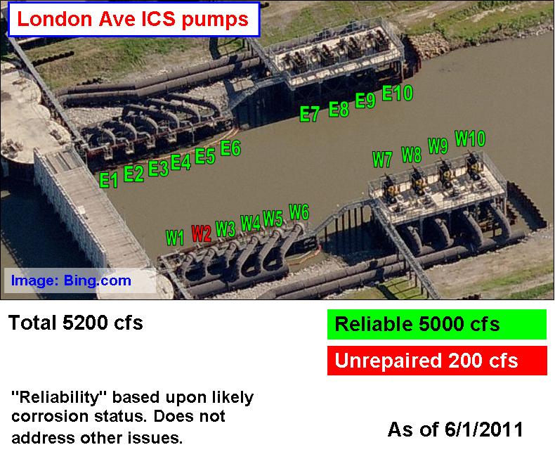
For much, much, more information regarding these pumps, two others at 17th Street out at the same time, and the contracting and repair activities surrounding them - including pictures from Conhagen repair reports - see the previous post, "The 2011 pump rebuild scramble."

That post includes all the information on the last eight pumps to be repaired before June 1, 2011.


As I reported in May of this year, hydraulic pumps W5 and W6 at the London Avenue closure site were removed for complete rebuilding in late April, likely on the 26th. Here's the empty slots:


We can tell these pumps were pulled out because we can see the bottom flanges of the elbows unattached to any pumps below them. We also don't see the distinctive piping extensions added to the pumps in 2007, as we could on the adjacent pump W4.

I can report that W5 and W6 went back in at the end of May:


This means that 11 of the 12 hydraulic pumps at the London Avenue site have been overhauled due to severe corrosion of all their internals:


None of the contract documents received from the Corps as of July 13, 2011 indicate pump W2 was ever pulled out.

Also, it must be emphasized that the "reliability" shown in the graphic above only refers to the corrosion status of the pumps. It does not address any of the issues uncovered by Ms. Maria Garzino or myself.

Steve Beatty of The Lens contributed to this report.

Labels:

Thursday, June 16, 2011

Debris Part 6

Part 1
Part 2
Part 3
Part 4
Part 5
Part 7
Part 8
Part 9
Part 10
Part 11
Part 12
Part 13
Part 14

In the last part of this series, I noted that at least 8 Corps hurricane protection projects spanning 21.9 miles of west bank levee had been found to be contaminated with disturbingly large amounts of debris, including wood, rocks, concrete, bricks, and steel:


This information is thanks to SLFPA-W inspectors (provided by the state of Louisiana) who have been scrupulously documenting the problem for months.

On Sunday, June 12, 2011, the Times-Picayune's Paul Rioux had an excellent article on the front page about the whole debris issue. Titled "West Bank levee work faulted for excessive debris in dirt," the article hit all the high points this series has covered over the previous five parts, while filling in a number of holes. The best part is it did so much more concisely than I have. The T-P's editorial board followed up with an editorial two days later emphasizing the importance of overcoming the persistent debris problems across the west bank.

The article began with the unveiling of debris project number 9: WBV-3b (contractor: Shavers-Whittle). It's a little over a mile long on the east bank of the Harvey Canal, as shown on this map:


The project is substantially complete, so the 2011 inspection record has been understandably scanty. Most of the inspections took place during construction in 2009 and 2010. The last inspection in 2010 noted debris in the completed levee. From the July 13, 2010 report of the July 8, 2010 inspection:
"Ruts, organic matter, concrete/rocks and grass issues. (south end to gas line)"

"Ruts, organic matter, concrete/rocks and grass issues. (gas line to levee/flood wall transition)"

A few debris pictures were included:


The T-P article describes a piece of debris dug out by SLFPA-W employees on Monday, June 6, 2011:
"While inspecting a nearly finished levee south of Harvey on Monday, West Bank levee authority officials spotted a chunk of wood protruding near the levee’s crown, so they grabbed some shovels and started digging and digging and digging.

Twenty minutes and two broken shovels later, they had unearthed a log the size of a typical suitcase.

'If they’ve got a 200-pound log buried in that levee, it makes you wonder what else is buried there,' said Giuseppe Miserendino, the levee authority’s regional director. 'How does your quality-control person miss something that big? What else didn’t they catch?'"

Indeed.

So even though the publicly available record doesn't indicate debris problems, I'm still going to add WBV-3b to the map:


[Note: On June 15, 2011, just three days after the Times-Picayune published their article, SLFPA-W inspectors returned to WBV-3b to continue the pre-final inspection they started on June 6, 2011, when the log described above was unearthed. From a letter sent by SLFPA-W President Susan Maclay to the Corps on July 15, 2011, we learn that there were multiple trailers' worth of debris dug out of the WBV-3b levee that day. SLFPA-W inspectors got this photo of a log in one of those trailers:


That looks much bigger than the one featured in the Times-Picayune.

But what is way worse is what we can see when the camera pulls back:


Clearly, there are substantial debris problems with the completed levee at WBV-3b. There's more on this in Part 8 of this series.]

Regarding quality, Rioux got a quote from Julie Vignes, the Corps' top person on the west bank:
"'We will make sure everyone is comfortable that the levees meet the quality mark that we all want,' [Vignes] said. 'We have a very good working relationship with the levee authority inspectors. They find things, we find things, and we work together to resolve them.'"

We'll discuss the considerable issues with quality and the Corps' skewed view of it later. But it is worth pointing out how that "very good working relationship" gets expressed on the ground. Exhibit A comes from the latest SLFPA-W inspection report of deeply troubled project WBV-14c.2. This inspection is the one the Times-Picayune's Susan Poag photographed for the article on June 10, 2011. The report begins:
"SLFPAW reps arrived at the construction trailers at 10:22am and met with Jeremy George (USACE), Chad Thibodeux (USACE), Lauren Fagerholm (USACE), and Susan Poag (Times-Picayune). USACE conducted site visit while remaining 50 yds behind SLFPAW reps. USACE also video-recorded SLFPAW reps throughout site visit."

Susan Poag's photo of this inspection indeed shows one of the Corps personnel holding a video camera.

I guess the Corps is so high on their working relationship with SLFPA-W, they wanted to record it for all posterity and replay it when they were feeling blue.

But seriously, we've seen this sort of paranoia before. Remember this Corps employee photographing The Lens' Steve Beatty on October 12, 2010?


Mr. Beatty was photographing a rusty hydraulic pump being pulled out at the Orleans Avenue closure structure. The Corps doesn't like people watching them, and their first creepy instinct seems to be to photograph the watchers to get - I don't know - something incriminating? I don't get it.

Anyhow, WBV-14c.2 plays a feature role in Mr. Rioux's article. It is one of the worst projects for debris, with multiple avenues for non-clay material to find its way into the new levee, and constant reports dating back to last fall documenting many debris issues. The T-P article focuses on just one of those issues - wood chips.

We looked at the SLFPA-W reports on wood chips from March and April of this year in Part 1. The T-P refers to the March 24, 2011 inspection record:
"SLFPAW representatives expressed their concerns about the debris in the material in the levee, and the material that is being hauled in to Jeremy George (USACE). The current lift is being placed on top of a questionable amount of debris before the problem has been resolved; this may raise concerns of acceptability."

That report includes pictures like this:


Rioux's article notes:
"Corps specifications permit isolated pieces of wood as long as they are shorter than 12 inches, have a cross section less than 4 square inches and comprise no more than 1 percent of the levee material’s volume.

Miserendino said corps officials assured him the wood chips did not exceed the 1 percent threshold. But he said a team of 10 state geotechnicians determined April 1 that the chips amounted to 1.8 percent of the material in some spots, nearly twice the corps’ limit."

The state wisely did not trust the Corps to do their own analysis. I have a copy of the final report done by the state's consultant here.

Here's the Corps' Ms. Vignes' response from the T-P article:
"Vignes said that the overall average was less than 1 percent and that the tests indicated there was a 'very small' chance the wood chips would cause the levee to settle prematurely."

Slabbed had an interesting reaction to this quote:
"Julie hon, if we stuck one end of you in an oven at 500 degrees and the other half of you in a vacuum chamber at -400 degrees your overall average temperature is a comfy cool 50 degrees. Levees, like your body need complete continuity (in the case of levees that of quality construction) to survive intact and you of all people should know that."

My response is a little less heated. Taking a look at the actual report, we find the state's consultant, GeoEngineers of Baton Rouge, took six samples on April 20th (it appears the Times-Picayune got the date wrong) and analyzed them for wood content. their findings on the numbers are unambiguous:
"Wood content ranged from 0.1% to 1.8% by volume and 0.01% to 0.03% by weight, based on total volume and weight (soil + wood)"

There was no "overall average" reported. Ms. Vignes was totally just making that up.

In the T-P article, Vignes continued:
"Noting that the levee is being raised in layers up to a foot deep, she said the inspectors arrived before workers had picked debris from a new layer of dirt."

"Vignes said the corps determined the material was from a new pit that, as is often the case, had roots and other woody debris near the surface. She said the pit had been excavated deep enough that the debris was no longer an issue, so the contractor continued using it."

So here's the Corps explanations:

a) Yes the amount of debris is over the 1% specification, but only in a relatively tiny portion of the levee. If you look at the whole 3.5 miles, it's fine! This is known as the "Tony Hayward" defense.

b) Also, SLFPA-W came early. They didn't give us a chance to clean the place up!

c) Finally, the borrow pits had wood chips, but they don't now. So ignore all those reports and pictures of other wood, rocks, concrete, bricks, and steel before, during, and since this particular wood chip problem.

I don't think Corps Public Affairs will be putting Ms. Vignes in front of any more reporters. Also, if her quotes indicate how the Corps gets the levees to "meet the quality mark that we all want," it seems clear that "quality" desn't mean the same thing in Corps-speak as it does in the real world.

Mr. Miserendino ably rebuts Ms. Vignes' last two arguments in the T-P article:
"Miserendino said wood chips were present at each of the authority’s subsequent weekly inspections. "Every time we questioned the amount of debris, the response was always the same, 'Oh, we haven’t picked it yet,'" he said."

Indeed, the next SLFPA-W inspection report, from the March 31, 2011 inspection says:
"Debris in the material that is being hauled in from Sta.55+00 to Sta 25+00. Area has not been picked yet but USACE assured SLFPAW representatives that this area would be picked before the next levee lift was placed."

But the wood chips persisted. Two weeks after the March 24th inspection, they were widely distributed. The report on the April 7, 2011 inspection noted:
"Site visit began on the floodside of the levee between Sta.0+44 to Sta 55+00. The material that is being hauled in contains a considerable amount of debris and is being picked out. Pickers were at approx. Sta.15+00 during site visit. Levee lifts are being placed on top of an abundant amount of small wood chips (within spec size) in this area. Phylway reps informed SLFPAW that USACE stopped hauling of material to this area until the problem is further investigated."

The pictures tell the tale:


This report further undercuts Ms. Vignes' reasurances. Even when some debris was being picked up, most of it was still getting buried into the levee.

Mr. Rioux's article finally notes that no matter what the Corps says, the debris problems have continued unabated at WBV-14c.2, noting the June 2nd report says "debris throughout the jobsite continues to be an issue."

After the article was published, an even more recent report was made available. It is from June 10th and like the June 2nd report, it's more of the same. In addition to the palpable mistrust between the Corps and SLFPA-W ("USACE also video-recorded SLFPAW reps throughout site visit"), the same old debris concerns are there:
"Levee:
- East end of project (Sta.182+00 to 162+00):
A noticeable amount of debris was found on the protected side berm and on the levee in this area. USACE informed SLFPAW reps that this area had not been picked yet.
- East end of project (Sta.162+00 to Sta.120+00):
A noticeable amount of debris was also found on the protected side berm in this area. Sta.150+00 to Sta.162+00 had been picked earlier in the week. Sta.150+00 to Sta.120+00 had been picked a few weeks prior to inspection.
- North/South levee (Sta.70+00 to Sta.112+00):
A fair amount of debris was found on the levee section in this area.
- West end of project (Sta.15+00 to Sta.0+00):
Inspected area where contractor had stopped degrade operation. A small amount of debris was found was found on top of the levee in this area."

Just as Mr. Miserendino predicted, the Corps claimed the "area had not been picked yet." To which I - and likely the SLFPA-W inspectors after all the other times they had heard that - would ask, "Why the hell not?"

You could almost hear the SLFPA-W inspector sigh as he typed the wrap up of the visit:
"Debris throughout the jobsite continues to be an issue. East end of project (Sta.182+00 to 120+00) will need to be picked again; including areas that were picked earlier in the week. North/South levee (Sta.70+00 to Sta.112+00) will need to be repicked prior to seeding of the levee in this area. West end of the project (Sta.15+00 to Sta.0+00) where degrade operation had stopped will need to be re-picked also."

The SLFPA-W inspector reinforces the point with 21 pages of pictures of rocks, wood, and other detritus like these:


I'm sure the Corps got great video of those pictures being taken.

Further details on the copious problems at WBV-14c.2 can be found in parts 1 and 4 of this series. Those problems would seem to be tightly wound up with the contractor on the project (Phylway) and the dirt supplier (River Birch).

Rioux's article provides confirmation of the link between the River Birch pits and the multiple debris-laden projects in which Phylway has been involved (see Part 5 for specifics on those projects), while providing more detail:
"Officials with Phylway Construction of Thibodaux, which has a $28.8 million contract to raise the [WBV-14c.2] levee, did not return a message seeking comment.

Vic Culpepper, River Birch’s technical director, emphasized that the corps approved all three of River Birch’s pits based on soil tests.

"In the past five years, we’ve supplied more than 2 million cubic yards of clay to more than 20 levee projects on the West Bank and never had an issue," Culpepper said. "That tells me the clay isn’t the problem."

He said River Birch simply leased a portion of one of its pits to Phylway, which excavated the dirt itself.

"How they process or handle it is up to them," Culpepper said. "I’m not saying they did it right or wrong, just that it wasn’t our responsibility."

Having seen the amount of debris in the dirt coming out of the River Birch pits, the argument they should be trusted because they have supplied 20 projects does not give a warm and fuzzy feeling.

Also, the mention of the lease between Phylway and River Birch firms up my suspicions about a contractual relationship between the two firms, but that doesn't seem to matter as River Birch's Culpepper seems more than willing to throw Phylway under the bus at the first question from a reporter.

Finally, River Birch's claim of "no issues" to a reporter, when it has taken subpoenas and FBI raids to get information out of River Birch in the federal investigation, is absurd in the extreme. I doubt they would reveal additional unpublicized problems to a reporter writing an article documenting the problems that have already been publicized through numerous inspection reports available on the internet.

Rioux's article notes the power of those inspection reports by recounting an incident involving the May 10, 2011 SLFPA-W inspection of project WBV-17b.2:
"Inspector David Roark concluded that the levee authority’s 'concerns about the debris appear to have been disregarded to meet the June mandate' to provide protection from a 100-year storm by the beginning of the just-begun hurricane season.

Miserendino said the scathing report elicited a series of calls from the corps official overseeing the project to try to rectify the problem.

'After we called them out, the contractor hired more people to pick debris,' Miserendino said. 'They handled that quite well.'"

I must say that story sounds good. The WBV-17b.2 inspection reports show a slightly more nuanced set of events. After the May 10th report, there were actually more pictures of debris in the next report (30 vs. 29), though the debris in the subsequent report does seem to be smaller.

As noted in Part 5, that following WBV-17b.2 inspection, on May 23, 2011, featured the Corps inspector - Larry Pryor - pushing to finish the levee in advance of the June 1 deadline, and the SLFPA-W (represented by David Roark) insisting (rightly) that it's not acceptable.
"Overall review of site visit:
Levee is completed to construction elevation with the exception of two areas. The first at the east entrance levee construction crossing for WBV-72 and the second at the discharge pipe construction crossing for WBV-76.

USACE inspector expressed that the contractor believes the levee has been constructed to plans and specs and is ready for seeding; after reviewing the levee it appears to still have high and low areas along the top and sides of the levee. Also, debris was found along the top and sides of the levee.

Debriefing:
Before seeding, the levee needs to be graded, compacted and the debris removed (wood and concrete)."

So debris was still in the levee, even after the Corps sent more folks out there to clean it up:


As I mentioned above, these appear to be somewhat smaller debris pieces than the ones shown in the May 10th report, perhaps pointing to the increased efforts to pick debris reported by Mr. Miserendino. However, the effect of increased attention to debris was undercut by obvious wavyness of the levee:


Since the T-P article appeared, another WBV-17b.2 report has been made available. The report on the June 9, 2011 inspection, shows that the impact of the May 10th report was probably temporary. The report says:
"- The crown and side slopes of the levee still contains high and low areas which will need to be corrected. Unless the contractor believes the levee is construction to plans and specs there should be grade stakes along the project for control points for final grade and compaction.
- Rocks/concrete and wood debris still exist; need to remove before seeding."

"Debris, mostly rocks/concrete was noted during today's visit. SLFPA-W and the USACE representative picked up and placed most of the found debris in small piles along the levee."

The debris photos (17 of them, admittedly fewer than before) show the rocks and concrete:


And the wavyness in the levee remains as well:


Based on the reports since May 10th, it appears the Corps and the contractor (Healtheon) remain ultimately unresponsive to not only debris concerns, but also other major issues of quality.

Mr. Miserendino and the SLFPA-W insepctors have good reason to worry about such quality issues. Mr. Rioux's article notes:
"Miserendino emphasized that the debris problem isn’t so severe that he fears a catastrophic levee failure could put people’s lives and homes at risk. Instead, he’s worried the unsuitable material will cause the levees to subside prematurely, sending the authority’s maintenance costs skyrocketing.

'Do I think these levees are going to blow out? Do I think they’re going to fail? No,' he said. 'But do I think we could face a significant maintenance nightmare that will cost Jefferson Parish taxpayers a lot of money? Yes.'"


Mr. Miserendino's concerns about maintenance dollars are legitimate, since the SLFPA-W is currently looking at future bills for maintenance of this system which they know they cannot afford. Any additional problems would distract from keeping the good stuff maintained.

Also, I have to note that Mr. Miserendino may be slightly optimistic, since we don't really know what else is in these levees. According to their reports, the SLFPA-W inspectors only started clamping down on debris in the last half of 2010, but levee construction has been going nearly continuously since 2005. Indeed, on troubled project WBV-14c.2, the existing levee - which was being used to build the new levee - was so contaminated with debris that the dirt from it was ripped off the project and thrown away. How many other spots like that - of which Mr. Miserendino and the public are unaware - lie beneath the miles of levee under construction the last six years?

Put this together with the Corps videotaping the SLFPA-W inspectors, the unending problems with debris on multiple projects, the blatant ignoring of SLFPA-W inspectors' documented concerns, the need for the SLFPA-W to go to the paper to get their concerns heard, and the Corps' relentless, ultimately failed drive to finish on June 1, 2011. Despite what the Corps claims, it is clear the relationship between the Corps and the SLFPA-W is toxic, and that the Corps' side is powered not by a desire to do things right - or even according to their own specifications - but to just do things fast with little regard to quality and lots of deference to contractors' wishes over those of the SLFPA-W. I know no one likes having their mistakes pointed out, but Mr. Miserendino says it best at the end of the T-P article:
"'We’re not going to get another bite at the apple. We’re not going to have another $14 billion dropped on us,' he said, referring to the total cost of post-Hurricane Katrina flood-protection improvements across the New Orleans area. 'We’ve got one shot at this, and we’ve got to get it right.'"

Labels:

Tuesday, June 07, 2011

Still to come

A while back I reported briefly on what I believe was a massive outage of the Corps' control and monitoring systems (called "SCADA" systems) along all three New Orleans outfall canals in December, 2009.

The entry was based on a massive amount of SCADA data (multiple gigabytes) I received through FOIA requests of the Corps New Orleans District. The data covers about two years' worth of readouts from every level gauge and every sensor on every pump along the the London Avenue canal. It also covers about a year's worth of the equivalent data on the 17th Street and Orleans Avenue canals. The London Avenue data runs from mid-2008 through mid-2010, while the 17th Street and Orleans Avenue data runs from mid-2009 through mid-2010. The data is logged every ten seconds.

Due to how the Corps preserves and overwrites this data, I believe I am probably the only person that now has this information. It includes run data for four of the six storm-related closures of the Interim Closure Structures since 2006. That is, I've got data every 10 seconds during the two closures at the London Avenue canal in September and November, 2009, as well as the two 2008 closures at London Avenue (Gustav and Ike). The data doesn't include the 17th Street closures during Gustav and Ike. I've also got data on every time the pumps were turned on during the mid-2008 or mid-2009 (depending on canal) through mid-2010 period noted above. This likely represents the only true data on how the Corps' lakefront pumps actually run. I should be able to match it up with the pump logs I've obtained from the New Orleans Sewerage & Water Board, showing how much water was pouring into the canals when the Corps pumps were supposed to be pulling it out.

Prior to this, the only other run data released to the public was a highly redacted set of partial data for the 17th Street and London Avenue canals during Gustav and Ike, sent to Molly Peterson as part of a FOIA request for her 2009 "Pumps Under Pressure" report. With my SCADA data, I'll be able to see if the data sent to her was valid.

I'll be bringing out some analysis around this soon. It's a lot of data to crunch, so it takes a while. But maybe this will answer some questions that have lingered for a very long time...

Go to older posts Go to newer posts